- 1965 Twin Cities tornado outbreak
-
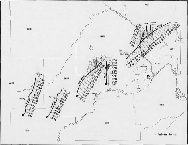
1965 Twin Cities tornado outbreak Tornado tracks through Twin Cities Metro Area
Date of tornado outbreak: May 6, 1965 Duration1: 2 hours, 6 minutes (6:08 PM to 8:14 PM CST) Maximum rated tornado2: F4 tornado Tornadoes caused: 6 Damages: Estimated $51 Million[1] Fatalities: 13 (683 injured)[2] Areas affected: Twin Cities (Minnesota) 1Time from first tornado to last tornado
2Most severe tornado damage; see Fujita ScaleThe 1965 Twin Cities tornado outbreak was the outbreak of six strong tornadoes that occurred around Minneapolis and St. Paul, Minnesota, USA on May 6, 1965. It has been nicknamed "The Longest Night" and is most often remembered for the two F4 tornadoes that hit Fridley, Minnesota. Thirteen people were killed in the six tornadoes that touched down in the Twin Cities area that day. Four tornadoes were rated F4, one was rated F3, and other was rated F2. This event caused more dollar damage than any single weather event in Minnesota history at that time.[1] It was voted a tie for the "fifth most significant Minnesota Weather Event of the 20th Century" with the 1965 Mississippi & Minnesota River Flooding by the Minnesota Climatology Office.[3]
Contents
Outbreak description
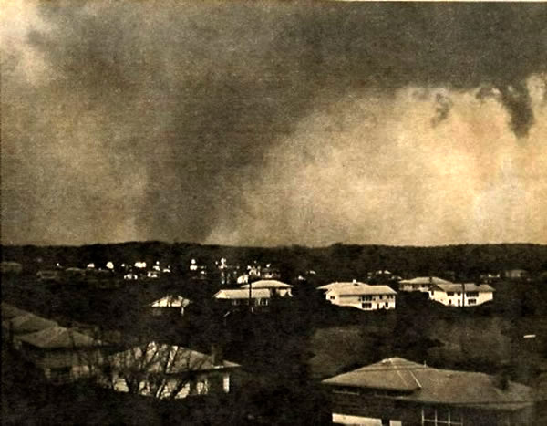
 A tornado over Minnetonka, Minnesota.
Temperatures on May 6 were in the upper 70s with high dewpoints, which was considered to be unusual for early May in Minnesota.[1] A strong upper level system moving in from the southwest and a nearby slow-moving cold front helped spark the storms. These storms formed as training supercells; an atmospheric phenomenon that is extremely rare in Minnesota. Because of the training, the same general areas from Sibley County through Carver and Hennepin and into northwestern Ramsey counties kept getting the brunt of these cells.
Considering this outbreak occurred just three weeks after the Palm Sunday tornado outbreak, quick and successful warnings from the U.S. Weather Bureau and transmission from WCCO Radio kept the death toll relatively low. This was also the first time in Minnesota state history where civil defense sirens were used for severe weather purposes.
The first tornado touched down at 6:08 pm just east of the town of Cologne in Carver County. According to the U.S. Weather Bureau, this twister was rated an F4, killed three people, and injured 175. An F2 tornado that touched down in Sibley County at 6:43 pm killed one person and also injured 175 others.
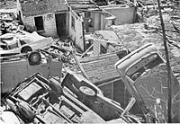 Tornado damage in Fridley, Minnesota.
Two tornadoes touched down in Fridley, just over an hour apart. In all, six people were killed in the Fridley tornadoes and over 180 were injured. Over 450 homes were destroyed in Fridley, and neighboring Mounds View also sustained heavy damage. A man who called WCCO radio after the first Fridley tornado claimed on air that he had been in his car when the tornado hit and that the tornado blew out his car windows. Although he is widely believed to have been killed by the second Fridley twister later that night (which did kill a 26-year-old man with a similar name), the caller was actually a teacher at Fridley Junior High School who survived. The tornado also damaged the sign adorning the Heights Theater in Columbia Heights. Photographs for the earlier Deephaven and second Fridley tornado were published in the Minneapolis Tribune (now Star Tribune) newspaper. Early radar images show the supercells as they moved through the area.[2]
Confirmed tornadoes
Outbreak death toll State Total County County
totalMinnesota 13 Anoka 3 Carver 3 Hennepin 6 Sibley 1 Totals 13 All deaths were tornado-related - Table of confirmed tornadoes - after surveys by local weather service offices
Confirmed
TotalConfirmed
F0Confirmed
F1Confirmed
F2Confirmed
F3Confirmed
F4Confirmed
F56 0 0 1 1 4 0 F# Location County Time (UTC) Path length Damage F4 E of Cologne Carver 1408 13 miles (21 km) Tornado touched down just east of Cologne in Carver County and dissipated in the northwestern portion of Minnetrista in Hennepin County after being on ground for 13 miles (21 km). It killed three people and injured 175. F4 Chanhassen Carver 1427 7 miles (11 km) Tornado touched down near Lake Susan in Chanhassen and traveled 7 miles (11 km) toward Deephaven in Hennepin County. It resulted in no injuries or fatalities. F3 E of New Auburn Sibley 1434 16 miles (26 km) Tornado touched down about 3 miles (4.8 km) east of New Auburn in Sibley County and moved to just west of Lester Prairie in McLeod County. It was on the ground for 16 miles (26 km), but there were no injuries or fatalities. F2 E of Green Isle Sibley 1443 11 miles (18 km) Tornado touched down about two miles (3 km) east of Green Isle in Sibley County and was on the ground 11 miles (18 km). It dissipated about two miles (3 km) southwest of Waconia in Carver County. It killed one person and injured 175. F4 Fridley Anoka 1506 7 miles (11 km) Tornado touched down in the southwesternmost corner of Fridley in Anoka County and moved across the Northern Ordnance plant, and dissipated just northeast of Laddie Lake in Blaine in Anoka County. It was on the ground for 7 miles (11 km), killed three people, and injured 175. F4 Golden Valley Hennepin 1614 18 miles (29 km) Tornado touched down in Golden Valley in Hennepin County and moved across north Minneapolis, Fridley in Anoka County, Mounds View in Ramsey County, and dissipated just west of Centerville in Anoka County after being on the ground for 18 miles (29 km). It killed six people and injured 158. Source: National Climatic Database Center See also
References
- ^ a b c Lattery, Robert. "Six Deadly Twisters". Archived from the original on 2009-07-21. http://www.lattery.com/vortex100/intro.htm. Retrieved 2006-12-25.
- ^ a b "The May 6, 1965 Tornadoes". NOAA. 2005-10-29. http://www.crh.noaa.gov/mpx/HistoricalEvents/1965May06/index.php. Retrieved 2006-12-25.
- ^ Significant Minnesota Weather Events of the 20th Century, Minnesota Climatology Group (University of Minnesota)
External links
- May 6, 1965 Tornado Outbreak (NWS Twin Cities, MN)
- Radiotapes.com Aircheck recordings of WCCO Radio's tornado coverage from May 6, 1965.
Categories:- F4 tornadoes
- Tornadoes of 1965
- Tornadoes in Minnesota
- 1965 in Minnesota

Wikimedia Foundation. 2010.