Noordpeene

Noordpeene

Noordpeene

Noordpeene is located in France
{{{alt}}}
Noordpeene
Administration
Country France
Region Nord-Pas-de-Calais
Department Nord
Arrondissement Dunkerque
Canton Cassel
Intercommunality pays de Cassel
Mayor Jacques Drieux
(2008–2014)
Statistics
Elevation 0–68 m (0–223 ft)
(avg. 27 m/89 ft)
Land area1 17.12 km2 (6.61 sq mi)
Population2 674  (1999)
 - Density 39 /km2 (100 /sq mi)
INSEE/Postal code 59436/ 59670
1 French Land Register data, which excludes lakes, ponds, glaciers > 1 km² (0.386 sq mi or 247 acres) and river estuaries.
2 Population without double counting: residents of multiple communes (e.g., students and military personnel) only counted once.

Coordinates: 50°48′23″N 2°23′53″E / 50.8064°N 2.3981°E / 50.8064; 2.3981

Noordpeene is a commune in the Nord department in northern France.

The small river Peene Becque flows through the village.

Heraldry

Arms of Noordpeene

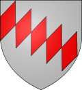
The arms of Noordpeene are blazoned :
Argent, 5 fusils conjoined in bend gules. (probably not heraldically different from West-Cappel)


See also

References


Wikimedia Foundation. 2010.

Игры ⚽ Поможем решить контрольную работу

Look at other dictionaries:

  • Noordpeene — Noordpene …   Wikipedia Español

  • Noordpeene — 50° 48′ 23″ N 2° 23′ 53″ E / 50.8064, 2.3981 …   Wikipédia en Français

  • Zuytpeene — 50° 47′ 41″ N 2° 25′ 39″ E / 50.7947, 2.4275 …   Wikipédia en Français

  • Peene Becque — Gewässerkennzahl FR: E4900700Vorlage:Infobox Fluss/GKZ FR Lage Frankreich, Region Nord Pas de Calais …   Deutsch Wikipedia

  • Buysscheure — 50° 48′ 14″ N 2° 19′ 53″ E / 50.8039, 2.3314 …   Wikipédia en Français

  • Cassel (Nord) — Pour les articles homonymes, voir Cassel. 50° 48′ 02″ N 2° 29′ 18″ E …   Wikipédia en Français

  • Jean-Baptiste Van Grevelynghe — Tisje Tasje Tisje Tasje et sa seconde épouse Toria Jean Baptiste Van Grevelynghe dit Tisje Tasje (1765 1842), est un personnage semi légendaire dont la ville d Hazebrouck a fait un de ses géants. Réalisé par Maurice Deschodt en 1947, il symbolise …   Wikipédia en Français

  • Mont Cassel — Cassel (Nord) Pour les articles homonymes, voir Cassel. Cassel Cassel, vue du clocher Administration Pays …   Wikipédia en Français

  • Nieurlet — 50° 47′ 24″ N 2° 16′ 59″ E / 50.79, 2.28305555556 …   Wikipédia en Français

  • Ochtezeele — 50° 49′ 04″ N 2° 24′ 10″ E / 50.8177777778, 2.40277777778 …   Wikipédia en Français

Share the article and excerpts

Direct link
Do a right-click on the link above
and select “Copy Link”