- Colleret
-
Colleret


 ColleretLocation within Nord-Pas-de-Calais region
 Colleret
Administration Country France Region Nord-Pas-de-Calais Department Nord Arrondissement Avesnes-sur-Helpe Canton Maubeuge-Sud Intercommunality Maubeuge Val de Sambre Mayor Bernadette Lejuste
(2008–2014)Statistics Elevation 138–214 m (453–702 ft)
(avg. 181 m/594 ft)Land area1 18.79 km2 (7.25 sq mi) Population2 1,649 (1999) - Density 88 /km2 (230 /sq mi) INSEE/Postal code 59151/ 59680 1 French Land Register data, which excludes lakes, ponds, glaciers > 1 km² (0.386 sq mi or 247 acres) and river estuaries. 2 Population without double counting: residents of multiple communes (e.g., students and military personnel) only counted once. Coordinates: 50°15′26″N 4°04′36″E / 50.2572222222°N 4.07666666667°E
Colleret is a commune of the Nord department in northern France.
Heraldry
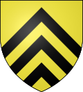
The arms of Colleret are blazoned :
Or, 3 chevrons sable. (Bersillies, Boeschepe, Boussières-sur-Sambre, Colleret, Cousolre, Flaumont-Waudrechies, Hautmont, Limont-Fontaine, Lompret, Masny, Neuville-en-Avesnois and Saint-Rémy-du-Nord use the same arms)See also
References
Categories:- Communes of Nord
- Nord geography stubs


Wikimedia Foundation. 2010.