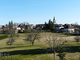
- Négrondes
-
Négrondes
Administration Country France Region Aquitaine Department Dordogne Arrondissement Périgueux Canton Savignac-les-Églises Intercommunality Villages truffiers des portes de Périgueux Mayor Claude Camelias
(2008–2014)Statistics Elevation 155–232 m (509–761 ft)
(avg. 174 m/571 ft)Land area1 20.15 km2 (7.78 sq mi) Population2 816 (2008) - Density 40 /km2 (100 /sq mi) INSEE/Postal code 24308/ 24460 1 French Land Register data, which excludes lakes, ponds, glaciers > 1 km² (0.386 sq mi or 247 acres) and river estuaries. 2 Population without double counting: residents of multiple communes (e.g., students and military personnel) only counted once. Coordinates: 45°20′43″N 0°51′54″E / 45.3452777778°N 0.865°E
Négrondes is a commune in the Dordogne department in Aquitaine in southwestern France.
Population
Historical populations Year Pop. ±% 1793 774 — 1800 623 −19.5% 1806 755 +21.2% 1821 950 +25.8% 1831 912 −4.0% 1836 960 +5.3% 1841 915 −4.7% 1846 906 −1.0% 1851 914 +0.9% 1856 932 +2.0% 1861 927 −0.5% 1866 939 +1.3% 1872 982 +4.6% 1876 1,011 +3.0% 1881 1,068 +5.6% 1886 976 −8.6% 1891 991 +1.5% 1896 947 −4.4% 1901 885 −6.5% 1906 968 +9.4% 1911 970 +0.2% 1921 817 −15.8% 1926 884 +8.2% 1931 798 −9.7% 1936 772 −3.3% 1946 831 +7.6% 1954 691 −16.8% 1962 635 −8.1% 1968 603 −5.0% 1975 565 −6.3% 1982 578 +2.3% 1990 664 +14.9% 1999 659 −0.8% 2008 816 +23.8% See also
References
Categories:- Communes of Dordogne
- Dordogne geography stubs
Wikimedia Foundation. 2010.


