- Naillat
-
Naillat

 Naillat
Administration Country France Region Limousin Department Creuse Arrondissement Guéret Canton Dun-le-Palestel Intercommunality Pays Dunois Mayor Jeanine Gillet
(2008–2014)Statistics Elevation 316–530 m (1,037–1,740 ft)
(avg. 360 m/1,180 ft)Land area1 36.23 km2 (13.99 sq mi) Population2 657 (2008) - Density 18 /km2 (47 /sq mi) INSEE/Postal code 23141/ 23800 1 French Land Register data, which excludes lakes, ponds, glaciers > 1 km² (0.386 sq mi or 247 acres) and river estuaries. 2 Population without double counting: residents of multiple communes (e.g., students and military personnel) only counted once. Coordinates: 46°15′55″N 1°38′18″E / 46.2652777778°N 1.63833333333°E
Naillat is a commune in the Creuse department in the Limousin region in central France.
Contents
Geography
A farming area comprising the village and several hamlets situated some 14 miles (23 km) northwest of Guéret at the junction of the D5, D14 and the D44 roads. A small tributary of the Creuse, the river Brézentine flows through the middle of the village.
Population
Historical populations Year Pop. ±% 1962 943 — 1968 1,084 +15.0% 1975 955 −11.9% 1982 809 −15.3% 1990 721 −10.9% 1999 641 −11.1% 2008 657 +2.5% Sights
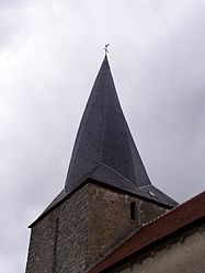
- The twelfth-century church, with a twisted spire.
- A feudal motte.
- Two menhirs.
- The château de La Vergne.
See also
References
External links
- Naillat on the Quid website (French)
Categories:- Communes of Creuse
- Creuse geography stubs


Wikimedia Foundation. 2010.