- Dooley, Montana
-
Dooley — Ghost town — Location of Dooley in Montana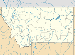
 Dooley
Coordinates: 48°52′52″N 104°23′22″W / 48.88111°N 104.38944°WCoordinates: 48°52′52″N 104°23′22″W / 48.88111°N 104.38944°W[1] Country United States State Montana County Sheridan Established 1913 Abandoned 1957 Elevation 2,461 ft (750 m) Dooley is a ghost town in northeastern Sheridan County, Montana, United States. The town was established as a station stop on the Soo Line Railroad branch line to Whitetail, Montana, constructed in 1913.
Although the land around Dooley attracted numerous homesteaders during the first years following the railroad's completion, the region proved to be unsuited for intensive agricultural use, and by the 1920s the town was in decline. Though the railroad remains in operation, Dooley is now a ghost town.
The post office at Dooley operated from 1914 to 1957.[2]
The only remaining building in Dooley is the long-abandoned Rocky Valley Lutheran Church, which was listed on the National Register of Historic Places in 1993.[3]
Notes
- ^ "Dooley". Geographic Names Information System, U.S. Geological Survey. http://geonames.usgs.gov/pls/gnispublic/f?p=gnispq:3:::NO::P3_FID:770722.
- ^ "Sheriden [sic] County Post Offices". Postalhistory.com. http://www.postalhistory.com/postoffices.asp?task=display&state=MT&county=Sheriden. Retrieved 2008-03-28.
- ^ "MONTANA - Sheridan County". National Register of Historic Places. http://www.nationalregisterofhistoricplaces.com/MT/Sheridan/state.html. Retrieved 2008-01-30.
Municipalities and communities of Sheridan County, Montana City 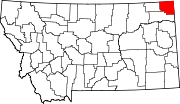
Towns CDPs Unincorporated
communitiesGhost town Dooley
Indian reservations Footnotes ‡This populated place also has portions in an adjacent county or counties
Categories:- Geography of Sheridan County, Montana
- Ghost towns in Montana
- National Register of Historic Places in Montana
- Montana geography stubs
- United States ghost town stubs


Wikimedia Foundation. 2010.