Baghdad Airport Road

Baghdad Airport Road
Iraqis make Arba`iniyah trek via Airport Road

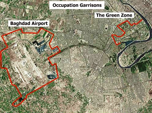
The Baghdad Airport Road is a 12 kilometer (7.5 mi) stretch of highway in Baghdad, Iraq linking the International Zone, a heavily fortified area at the center of Baghdad, to Baghdad International Airport (BIAP). It also links different parts of Baghdad to the Airport and connects neighboring areas to each other. It became prominent after the 2003 invasion of Iraq following its capture by the Coalition Forces. Although it was commonly referred to by the military Main Supply Route (MSR) designation Route Irish, the route from the International Zone to the airport stretches over two MSRs: Route Aeros, the section leading into and out of the International Zone, and Route Irish, which stretches east from the airport then turns south (past the junction with Route Aeros) to a junction with Highway 1 (MSR Tampa).

Due to heavy military traffic and high-profile convoys, the route from the International Zone to the airport was extremely dangerous in the years following the invasion. The many roadside bombs, suicide bombers attacking its checkpoints, drive-by shootings and random shooting from the areas on both sides of the road have led to its notoriety.[1] In late 2005 after aggressive patrolling by 2/5 Cavalry and later the American 69th Infantry Regiment,[2] the road became safer and more reliable.[3][4]

References

  1. ^ Sydney Morning Herald, The World's Most Dangerous Road
  2. ^ Flynn, Sean. The Fighting 69th: One Remarkable National Guard Unit's Journey from Ground Zero to Baghdad, Penguin Books, 2007
  3. ^ America's North Shore Journal, Route Irish, Safer and More Traveled
  4. ^ Washington Post, Easy Sailing Along Once-Perilous Road To Baghdad Airport


Wikimedia Foundation. 2010.

Игры ⚽ Поможем решить контрольную работу

Look at other dictionaries:

  • Baghdad — Infobox Settlement official name = Baghdad native name = بغداد nickname = imagesize = 300px image caption = General view of the north western part of Baghdad city across the Tigris, 2006. image mapsize = 300px map caption = The location of… …   Wikipedia

  • Baghdad International Airport — Not to be confused with Bagdad Airport. Baghdad International Airport مطار بغداد الدولي IATA: BGW – ICAO: ORBI …   Wikipedia

  • List of neighborhoods and districts in Baghdad — This article lists neighborhoods and the nine administrative districts within 50km of Baghdad, Iraq.The order is not alphabetical, but is instead arranged according to whether the neighborhood is east or west of the Tigris and then grouped… …   Wikipedia

  • Yarmouk, Baghdad — Yarmouk (Arabic,اليرموك) is a neighborhood in Southern Baghdad, Iraq near the Mansour district just north of the intersection of ‎Baghdad Airport Road and Hilla Road. It is a formerly upscale Sunni Muslim area that was once home to members of… …   Wikipedia

  • Baghdad — /bag dad, beuhg dad /, n. a city in and the capital of Iraq, in the central part, on the Tigris. 2,800,000. Also, Bagdad. * * * or Bagdad City (pop., 1999 est.: metro. area, 4,689,000), capital of Iraq. Located on the Tigris River, the site has… …   Universalium

  • Airport terminal — For other uses, see Terminal (disambiguation). Terminal 5 at London Heathrow Airport, United Kingdom, which is the world s busiest airport by international passenger traffic[1] …   Wikipedia

  • Road — This article is about a route, thoroughfare or way that supports travel by a means of conveyance. For a place outside a harbor where a ship can lie at anchor, see Roadstead. For public roads, see Highway. For other routes, see thoroughfare. For… …   Wikipedia

  • Road to Europe — Family Guy episode …   Wikipedia

  • Dubai International Airport — DXB redirects here. For the New Zealand locomotive operated by KiwiRail, see NZR DX class. Dubai International Airport مطار دبي الدولي …   Wikipedia

  • Tehran Imam Khomeini International Airport — IKA redirects here. For the Renault subsidiary, see Industrias Kaiser Argentina. Imam Khomeini International Airport Forudgāhe beynalmellaliye Imam Khomeini IATA: IKA – ICAO: OIIE …   Wikipedia

Share the article and excerpts

Direct link
Do a right-click on the link above
and select “Copy Link”