- Claveria, Cagayan
-
Claveria — Municipality — Map of Cagayan showing the location of Claveria.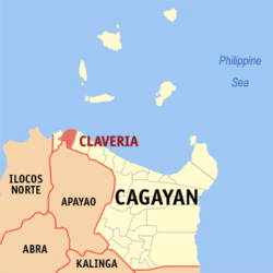 Location in the Philippines
 Claveria
Coordinates: 18°36′27″N 121°05′06″E / 18.6075°N 121.085°ECoordinates: 18°36′27″N 121°05′06″E / 18.6075°N 121.085°E Country  Philippines
Region Cagayan Valley (Region II) Province Cagayan District 2nd District Founded Barangays 41 Government - Mayor Hon. Celia T. Layus, MD Area - Total 194.80 km2 (75.2 sq mi) Population (2007) - Total 30,275 - Density 155.4/km2 (402.5/sq mi) Time zone PST (UTC+8) ZIP code 3519 Income class 3rd class Population Census of Claveria Census Pop. Rate 1995 25,363 — 2000 29,277 3.13% 2007 30,275 0.46% Claveria is a 3rd class municipality in the province of Cagayan, Philippines. According to the latest census, it has a population of 30,275 people in 5,767 households.
Claveria lies on the northwestern portion of the province of Cagayan. It is approximately 185.3 kilometers from Tuguegarao, the provincial and regional center of Cagayan Valley. It is approximately 613.0 kilometers from Manila via Ilocos Region. It is bounded on the north by the Babuyan Channel, on the east by the municipality of Sanchez-Mira; on the south by the province of Apayao and on the west by the municipality of Santa Praxedes. It was named after the Spanish governor-general Narciso Clavería y Zaldúa.
Barangays
Claveria is politically subdivided into 41 barangays.
- Alimoan
- Bacsay Cataraoan Norte
- Bacsay Cataraoan Sur
- Bacsay Mapulapula
- Bilibigao
- Buenavista
- Cadcadir East
- Cadcadir West
- Camalaggoan/D. Leaño
- Capannikian
- Centro I (Poblacion)
- Centro II (Poblacion)
- Centro III (Poblacion)
- Centro IV (Nangasangan)
- Centro V (Mina)
- Centro VI (Minanga)
- Centro VII (Malasin East)
- Centro VIII (Malasin West)
- Culao
- Dibalio
- Kilkiling
- Lablabig
- Luzon
- Mabnang
- Magdalena
- Malilitao
- Nagsabaran
- Pata East
- Pata West
- Pinas
- Santiago
- San Antonio (Sayad/Bimmokel)
- San Isidro
- San Vicente
- Santa Maria
- Santo Niño (Barbarnis)
- Santo Tomas
- Tabbugan
- Taggat Norte
- Taggat Sur
- Union
External links
- Claveria, Cagayan current Photos
- First Unofficial Website of Claveria, Cagayan
- Philippine Standard Geographic Code
- 1995 Philippine Census Information
- 2000 Philippine Census Information
- 2007 Philippine Census Information
Municipalities Abulug • Alcala • Allacapan • Amulung • Aparri • Baggao • Ballesteros • Buguey • Calayan • Camalaniugan • Claveria • Enrile • Gattaran • Gonzaga • Iguig • Lal-Lo • Lasam • Pamplona • Peñablanca • Piat • Rizal • Sanchez-Mira • Santa Ana • Santa Praxedes • Santa Teresita • Santo Niño • Solana • TuaoComponent city TuguegaraoSamahang ilocano Buloy
Categories:- Municipalities of Cagayan


Wikimedia Foundation. 2010.