- Colniza
-
Colniza — Municipality — The Municipality of Colniza Location of Colniza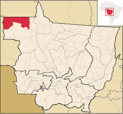
Coordinates: 09°32′38″S 57°26′56″W / 9.54389°S 57.44889°WCoordinates: 09°32′38″S 57°26′56″W / 9.54389°S 57.44889°W Country  Brazil
Region Central-West State  Mato Grosso
Founded November 26, 1998 Government – Mayor Sergio Bastos Dos Santos (PMBD) Area – Total 27.947.646 km2 (10.8 sq mi) Elevation 0 m (0 ft) Population (2008) – Total 29,636 – Density 0.5/km2 (1.3/sq mi) [1] Time zone UTC-4 (UTC-4) – Summer (DST) UTC-3 (UTC-3) Colniza is an agricultural [2] municipality in the Brazilian state of Mato Grosso. It has the highest homicide rate in Brazil [2], 165 deaths per year per 100 thousand inhabitants [3], and is also the westernmost municipality of the state
References
- ^ IBGE 2008 statistics
- ^ a b Tom Phillips (2008-01-25). "Amazon's rescue reversed". The Guardian. http://www.guardian.co.uk/brazil/story/0,,2246620,00.html. Retrieved 2008-01-25.
- ^ Lisandra Paraguassú (2007-02-28). "Pequenas cidades, muitos crimes" (in Portuguese). O Estado de São Paulo. http://clipping.planejamento.gov.br/Noticias.asp?NOTCod=339560. Retrieved 2008-01-25.
Municipalities of Mato Grosso Capital: CuiabáCentro-Sul Mato-Grossense Alto PantanalBarão de Melgaço • Cáceres • Curvelândia • PoconéAlto ParaguaiAlto Paraguai • Arenápolis • Nortelândia • Nova Marilândia • Santo AfonsoCuiabáChapada dos Guimarães • Cuiabá • Nossa Senhora do Livramento • Santo Antônio do Leverger • Várzea GrandeRosario OesteAcorizal • Jangada • Rosário Oeste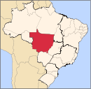
Nordeste Mato-Grossense CanaranaÁgua Boa • Campinápolis • Canarana • Nova Nazaré • Nova Xavantina • Novo São Joaquim • Querência • Santo Antônio do LesteMedio AraguaiaAraguaiana • Barra do Garças • CocalinhoNorte AraguaiaAlto Boa Vista • Bom Jesus do Araguaia • Canabrava do Norte • Confresa • Luciára • Novo Santo Antônio • Porto Alegre do Norte • Ribeirão Cascalheira • Santa Cruz do Xingu • Santa Terezinha • São Félix do Araguaia • São José do Xingu • Serra Nova Dourada • Vila RicaNorte Mato-Grossense Alta FlorestaAlto Teles PiresIpiranga do Norte • Itanhangá • Lucas do Rio Verde • Nobres • Nova Mutum • Nova Ubiratã • Santa Rita do Trivelato • Sorriso • TapurahArinosJuara • Nova Maringá • Novo Horizonte do Norte • Porto dos Gaúchos • São José do Rio Claro • TabaporãAripuanãAripuanã • Brasnorte • Castanheira • Colniza • Cotriguaçu • Juína • Juruena • RondolândiaColíderColíder • Guaranta do Norte • Matupá • Nova Canaã do Norte • Nova Guarita • Novo Mundo • Peixoto de Azevedo • Terra Nova do NorteParanatingaGaúcha do Norte • Nova Brasilândia • Paranatinga • Planalto da SerraParecisComodoro • Campo Novo do Parecis • Campos de Júlio • Diamantino • SapezalSinopCláudia • Feliz Natal • Itaúba • Marcelândia • Nova Santa Helena • Santa Carmem • Sinop • União do Sul • VeraSudeste Mato-Grossense Alto AraguaiaAlto Araguaia • Alto Garças • Alto TaquariPrimavera do LesteCampo Verde • Primavera do LesteRondonópolisDom Aquino • Itiquira • Jaciara • Juscimeira • Pedra Preta • Rondonópolis • São José do Povo • São Pedro da CipaTesouroAraguainha • General Carneiro • Guiratinga • Pontal do Araguaia • Ponte Branca • Poxoréo • Ribeirãozinho • Tesouro • TorixoréuSudoeste Mato-Grossense Alto GuaporeConquista d'Oeste • Nova Lacerda • Pontes e Lacerda • Vale de São Domingos • Vila Bela da Santíssima TrindadeJauruAraputanga • Figueirópolis d'Oeste • Glória d'Oeste • Indiavaí • Jauru • Lambari d'Oeste • Mirassol d'Oeste • Porto Esperidião • Reserva do Cabaçal • Rio Branco • Salto do Céu • São José dos Quatro MarcosTangará da SerraBarra do Bugres • Denise • Nova Olímpia • Porto Estrela • Tangará da SerraCategories:- Municipalities of Brazil
- Populated places in Mato Grosso
- Populated places established in 1998
- Brazil stubs


Wikimedia Foundation. 2010.