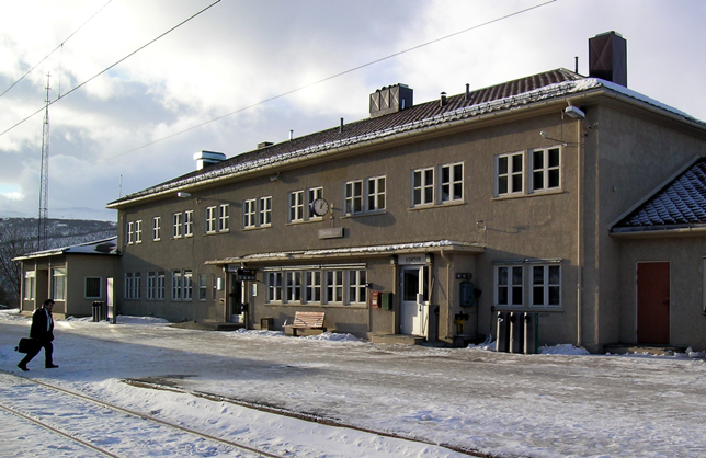
Dombås Station

Dombås Station
Dombås
Dombaas railway station.jpg
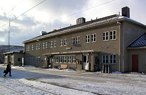
Location
Place Dombås
Municipality Dovre
Coordinates 62°4′5″N 9°7′31″E / 62.06806°N 9.12528°E / 62.06806; 9.12528Coordinates: 62°4′5″N 9°7′31″E / 62.06806°N 9.12528°E / 62.06806; 9.12528
Line(s) Dovre Line
Rauma Line
Distance 343.04 km (213.16 mi)
Elevation 659 m (2,162 ft) AMSL
Service
Opened 1913
Line operator(s) Norwegian State Railways
Connections

Dombås Station (Norwegian: Dombås stasjon) is a railway station located at Dombås in Dovre, Norway. The station is located on the Dovre Line as well as serving as the terminal station for the Rauma Line. The station is served by express trains on the Dovre Line and regional trains on the Rauma Line. The station was built in 1913 when the Dovre Line was extended to Dombås.

The restaurant was taken over by Norsk Spisevognselskap on 15 November 1924. The building burned down on 23 April 1940 during the German occupation of Norway. A kiosk was immediately opened, and remained in use until the new station building and restaurant opened on 1 July 1941.[1]

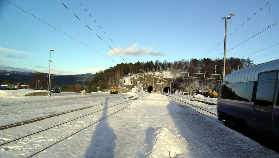
Looking north at Dombås Station, Dovrebanen heads into the right tunnel while Raumabanen heads into the left tunnel.

References

  1. ^ Just, Carl (1949) (in Norwegian). A/S Norsk Spisevognselskap 1919–1949. Oslo: Norsk Spisevognselskap. p. 61. OCLC 40310643. 
Preceding station Line Following station
Dovre Dovre Line Hjerkinn
Terminus Rauma Line Lesja
Preceding station Express trains Following station
Dovre   Oslo STrondheim S   Hjerkinn
Preceding station Regional trains Following station
Terminus   DombåsÅndalsnes   Lesja

Wikimedia Foundation. 2010.

Игры ⚽ Нужно сделать НИР?

Look at other dictionaries:

  • Dombås — The village of  Dombås (help·info) lies in the Dovre municipality and serves as an administrative center in the upper Gudbrandsdal, Norway. It lies at an important junction of roads: south leading to the current capital of Norway, Oslo, west …   Wikipedia

  • Battle of Dombås — Infobox Military Conflict conflict=Battle of Dombås caption=German Junkers Ju 52 downed at Dombås. partof=the Norwegian Campaign of World War II date=April 14–19, 1940 place=Dombås area in Dovre, Gudbrandsdal, Norway result=Norwegian tactical… …   Wikipedia

  • Bahnstrecke Åndalsnes–Dombås — Raumabanen Kylling bru über die Rauma Streckenlänge: 114 km Spurweite: 1435 mm (Normalspur) Legende …   Deutsch Wikipedia

  • Hotel Dombas (Dombas) — Hotel Dombas country: Norway, city: Dombas (City Centre) Hotel Dombas Location The Dombas hotel is located in the centre of this small town conveniently located where the e6 and e69 roads meet.Rooms All guest rooms in the hotel are located in the …   International hotels

  • Dovre Station — Dovre Location Place Dovre Municipality Dovre Coordinates …   Wikipedia

  • Hjerkinn Station — Infobox Norwegian station name = Hjerkinn caption = March 8, 1921 locale = Hjerkinn municipality = Dovre line = Dovrebanen distance = 381.74 km elevation = 1017.0 m asl coordinates = coord|63|13|12|N|9|32|27|E|type:railwaystation… …   Wikipedia

  • Lesja Station — Infobox Norwegian station name = Lesja caption = Train arriving on November 29, 1924 locale = Lesja municipality = Dovre line = Raumabanen distance = 360.68 km elevation = 634.1 m asl coordinates = coor dec|62.118672|8.853699 start = 1921… …   Wikipedia

  • Oppdal Station — Oppdal Location Place Downtown Oppdal Municipality Oppdal Coordinates …   Wikipedia

  • Kongsvoll Station — Infobox Norwegian station name = Kongsvoll caption = locale = Kongsvoll municipality = Oppdal line = Dovrebanen distance = 393.23 km elevation = 886.5 m asl coordinates = coord|62|18|26|N|9|36|20|E|type:railwaystation… …   Wikipedia

  • Berkåk Station — Infobox Norwegian station name = Berkåk caption = locale = Berkåk municipality = Rennebu line = Dovrebanen distance = 466.35 km elevation = 430 m asl coordinates = coord|62|49|20|N|10|0|58|E|type:railwaystation region:NO|display=title,inline… …   Wikipedia

Share the article and excerpts

Direct link
Do a right-click on the link above
and select “Copy Link”