McClure Pass

McClure Pass
McClure Pass

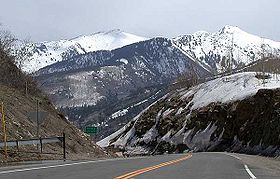
View north from the summit of McClure Pass towards the Elk Mountains near Marble
Elevation 2,671 m (8,763 ft)
Traversed by State Highway 133
Location
Location Gunnison / Pitkin counties, Colorado, USA
Range Rocky Mountains
Coordinates 39°07′44″N 107°16′59″W / 39.12901°N 107.28298°W / 39.12901; -107.28298
Topo map USGS Topozone entry

McClure Pass (el. 2671 m./8755 ft.) is a high mountain pass in the Rocky Mountains of western Colorado in the United States.

Overview

The pass is located along the boundary between Pitkin and Gunnison counties, in a gap at the western side of the Elk Mountains south of Redstone. It separates the headwaters of the Crystal River (a tributary of the Roaring Fork River to the north) with the headwaters of the North Fork Gunnison River (south). The pass is traversed by State Highway 133 between Carbondale and Paonia, providing the direct route between the Roaring Fork Valley and the North Fork Valley. The pass is not especially high and is generally open year round, closed only during heavy snowstorms. The approaches are fairly steep on each side, with an 8% grade. The approach is smooth on the south side, as the road overlooks Muddy Creek above Paonia State Park. The approach on the north side has one large switchback overlooking the valley containing the town of Marble.

External links

Coordinates: 39°07′44″N 107°17′02″W / 39.12901°N 107.28398°W / 39.12901; -107.28398


Wikimedia Foundation. 2010.

Игры ⚽ Поможем написать реферат

Look at other dictionaries:

  • McClure Pass — Vorlage:Infobox Pass/Wartung/Profil fehlt McClure Pass Blick vom Pass auf die Elk Mountains …   Deutsch Wikipedia

  • McClure-Pass — xx McClure Pass Blick vom Pass auf die Elk Mountains …   Deutsch Wikipedia

  • McClure — may refer to: McClure (surname) McClure s Magazine, a popular United States illustrated monthly magazine at the turn of the 20th century McClure (crater), an impact crater on the Moon In geography: McClure, British Columbia, Canada McClure,… …   Wikipedia

  • Robert McClure — Vicealmirante Robert McClure Nombre Robert John Le M …   Wikipedia Español

  • Colorado State Highway 133 — State Highway 133 Route information Maintained by CDOT Length: 71.4 mi …   Wikipedia

  • List of mountain passes — This is a list of mountain passes. Africa *Halfaya Pass *Moteng Pass (Lesotho) *Mahlasela pass (Lesotho)Asia* Khunjerab Pass Pakistan China (highest international border crossing at 4693 m.) * Khyber Pass Pakistan Afghanistan * Kotal e Lataband * …   Wikipedia

  • Colorado mountain passes — The following tables list some important mountain passes in the Rocky Mountains of the U.S. State of Colorado. Contents 1 High elevation Colorado highways not on a pass 2 Colorado mountain passes traversed by paved highways 3 …   Wikipedia

  • Southern Rocky Mountains — Range Mount Elbert is the highest peak of the Southern Rocky Mountains …   Wikipedia

  • Liste der befahrbaren Pässe in Colorado — Diese Liste befahrbarer Pässe im US Bundesstaat Colorado enthält alle asphaltierten Passstraßen, die einen Namen besitzen. Name Höhe in Meter Erschließung Wasserscheide I Wasserscheide II Cameron Pass 3132 State Route 14 Michigan River Joe Wright …   Deutsch Wikipedia

  • Pitkin County (Colorado) — Verwaltung US Bundesstaat: Colorado Verwaltungssitz: Aspen Adresse des Verwaltungssitzes: Gründung …   Deutsch Wikipedia

Share the article and excerpts

Direct link
Do a right-click on the link above
and select “Copy Link”