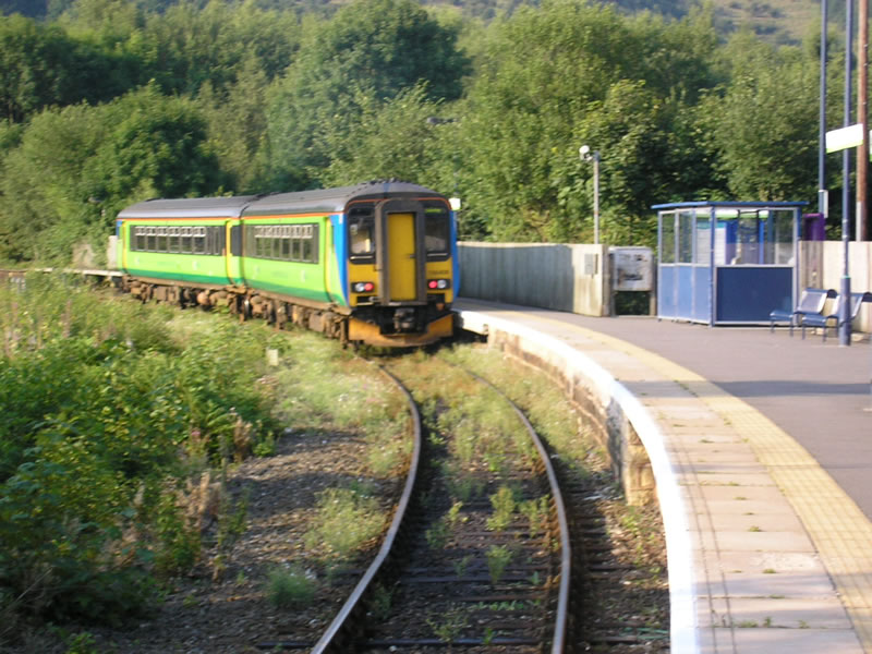
- Ambergate railway station
Infobox UK station
name = Ambergate
caption = Ambergate station as it is now
manager =East Midlands Trains
locale =Ambergate
borough =Amber Valley
code = AMB
lowusage0405 = 18,655
lowusage0506 = 19,006
lowusage0607 = 17,222
platforms = 1
years = 11 May 1840
events = Station opens as Amber Gate
years1 = 1 October 1846
events1 = Station renamed Ambergate
years2 = 1 June 1863
events2 = Station moved 400m due south
years3 = 10 December 1876
events3 = Station moved 605m due northAmbergate railway station is a
railway station serving the village ofAmbergate inDerbyshire . The station is located on theDerwent Valley Line fromDerby to Matlock, which diverges from theMidland Main Line just south of the station at Ambergate Junction.It has a complicated history. The original station was built for the
North Midland Railway in 1840, betweenDerby andLeeds . It was an ornate building, by Francis Thompson., which would have graced a Lord of the Manor.History
From
Belper the line ran along the Derwent Valley, along a stretch called Broadholme, with four bridges across the river, through Longlands Tunnel, across the River Derwent and Derby road with a magnificent five-arch viaduct. It then entered Hag Wood Tunnel as turned towards the Amber Valley.The station building was just north of this tunnel. Shortly afterwards a proposal was made for an
Ambergate, Nottingham, Boston and Eastern Junction Railway which however never materialised, apart from a stretch betweenColwick andGrantham .However, in 1849, the branch from Ambergate to
Rowsley was built by the proposedManchester, Buxton, Matlock and Midlands Junction Railway , with a west to north connection between the lines at the original Ambergate Junction. When a south to west connection was made, for trains from Derby to Rowsley, in 1863 the station building was rebuilt adjacent to the new Ambergate South junction. The original bridge was also widened at its northern end to accommodate the new junction.In 1867 the Rowsley line had reached New Mills, which meant that the
Midland Railway could operate from London toManchester andLiverpool .Another line in 1875 opened through Butterley to Pye Bridge, near
Ironville in theErewash Valley . Much of its business was coal traffic fromNottinghamshire to Manchester and Liverpool, avoiding Derby.The triangular station
In 1876 a loop was built passing the west side of Hag Wood Tunnel, as a diversion from the original line to a third platform, which allowed for Derby to
Sheffield stopping trains. The station was completely rebuilt, with the old building remaining in use a plans store. This third and final station was the famous triangular one, reputed to be one of only three in the country.Throughout the late nineteenth and early twentieth centuries, Ambergate was an important railway interchange with 28,207 tickets sold in 1872 rising to 90,157 by 1922.
In 1931 the line across Broadholme approaching from the south was upgraded to four tracks. Longlands Tunnel was opened up to form a wide cutting and the junction with the Manchester line was moved south of the river. A new modern steel bridge for the Manchester line was built alongside the original viaduct over the River Derwent and the A6 main road.
From Ambergate
From Ambergate, towards
Chesterfield , the next difficulty for the North Midland Railway was the intersection with theCromford Canal , where a complex aqueduct was built, before it carried on through a station at Wingfield to Stretton.The line through Matlock which, in those days, was the 'main line', carried London to
Manchester expresses such asthe Palatine and the Peaks. It also carried coal trains from Nottinghamshire, for a while with Garratt locomotives, which would be split at Rowsley for the long climb toPeak Forest .Grouping and Nationalisation
Having gathered in the
Midland Railway , the lines through the station became part of theLondon, Midland and Scottish Railway during the Grouping of 1923. The station then passed on to theLondon Midland Region of British Railways onnationalisation in 1948.When Sectorisation was introduced in the 1980's, the station was served by
Regional Railways until the Privatisation of British Railways.Decline
Most of the trackwork on the Manchester line was lifted in 1968 at the same time as the line from Rowsley to Manchester was closed. The station buildings were removed in 1970. Although the triangular station site remained for a number of years the road bridges were finally removed in the late 1980s. All that is left now is a platform on a single track to Matlock, and the original main Derby to Sheffield line through Hag Wood (Toadmoor) Tunnel, Clay Cross and Chesterfield. This led to its mention in the song "
Slow Train " byFlanders and Swann .ervices
The station is served by
East Midlands Trains , who operate local services from Derby to Matlock. For journeys beginning at Ambergate, tickets may be bought on the train for any destination in the country. (From Derby, tickets must be bought at the ticket office) Journey time to Derby is approximately 16 minutes. Services are approximately two-hourly. From 13 December 2008 it is planned to increase these to once an hour.Services are formed using
diesel multiple unit s of Classes 153, 156, or 158.rail line
previous = Belper
next = Whatstandwell
route =London Midland and Scottish Railway Midland Railway Manchester, Buxton, Matlock and Midlands Junction Railway
col = 000000rail line
previous = Whatstandwell
next = Wingfield
route =London Midland and Scottish Railway Midland Railway
col = 000000rail line
previous = Belper
next = Wingfield
route =London Midland and Scottish Railway Midland Railway North Midland Railway
col = 000000
###@@@KEYEND@@@###See also
*
Railway station layout References
* Pixton, B., (2000) "North Midland: Portrait of a Famous Route," Chelteham: Runpast Publishing
*
*External links
*GBvosi|e=434903|n=351657|cty=|txt=Map of the station in 1887 showing the triangular layout
* [http://www.picturethepast.org.uk/frontend.php?action=zoomWindow&keywords=Ref_No_increment;EQUALS;DMAG001910&prevUrl=ZnJvbnRlbmQucGhwPyZ1c2VyX2tleXdvcmRzPVBsZWFzZStlbnRlcit5b3VyK2tleXdvcmRzJm9wZXJhdG9yPUFORCZ0b3duX3ZpbGxhZ2U9QW1iZXJnYXRlJmRhdGFiYXNlPSZhY3Rpb249c2VhcmNoJmtleXdvcmRzPVRvd25fVmlsbGFnZSUzQkVRVUFMUyUzQkFtYmVyZ2F0ZSUzQiZ4PTUzJnk9OQ= "Picture the Past" Original station building at Ambergate]
* [http://www.picturethepast.org.uk/frontend.php?action=zoomWindow&keywords=Ref_No_increment;EQUALS;DMAG001911&prevUrl=ZnJvbnRlbmQucGhwPyZ1c2VyX2tleXdvcmRzPVBsZWFzZStlbnRlcit5b3VyK2tleXdvcmRzJm9wZXJhdG9yPUFORCZ0b3duX3ZpbGxhZ2U9QW1iZXJnYXRlJmRhdGFiYXNlPSZhY3Rpb249c2VhcmNoJmtleXdvcmRzPVRvd25fVmlsbGFnZSUzQkVRVUFMUyUzQkFtYmVyZ2F0ZSUzQiZ4PTUzJnk9OQ= "Picture the Past" Triangular Station circa 1910]
* [http://www.picturethepast.org.uk/frontend.php?action=zoomWindow&keywords=Ref_No_increment;EQUALS;DCHQ501686&prevUrl=ZnJvbnRlbmQucGhwPyZ1c2VyX2tleXdvcmRzPVBsZWFzZStlbnRlcit5b3VyK2tleXdvcmRzJm9wZXJhdG9yPUFORCZ0b3duX3ZpbGxhZ2U9QW1iZXJnYXRlJmRhdGFiYXNlPSZhY3Rpb249c2VhcmNoJmtleXdvcmRzPVRvd25fVmlsbGFnZSUzQkVRVUFMUyUzQkFtYmVyZ2F0ZSUzQiZ4PTUzJnk9OSZwYWdlPTI= "Picture the Past" View of the station]
Wikimedia Foundation. 2010.
