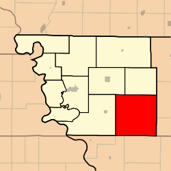
Dale Township, Atchison County, Missouri

Dale Township, Atchison County, Missouri
Dale Township
—  Township  —
Coordinates: 40°19′17″N 095°14′54″W / 40.32139°N 95.24833°W / 40.32139; -95.24833Coordinates: 40°19′17″N 095°14′54″W / 40.32139°N 95.24833°W / 40.32139; -95.24833
Country United States
State Missouri
County Atchison
Area
 - Total 81.58 sq mi (211.28 km2)
 - Land 81.56 sq mi (211.24 km2)
 - Water 0.01 sq mi (0.03 km2)  0.01%
Elevation[1] 971 ft (296 m)
Population (2000)
 - Total 245
 - Density 3/sq mi (1.2/km2)
FIPS code 29-18028[2]
GNIS feature ID 0766235

Dale Township is one of eleven townships in Atchison County, Missouri, USA. As of the 2000 census, its population was 245.

Contents

Geography

Dale Township covers an area of 81.58 square miles (211.3 km2) and contains no incorporated settlements. It contains one cemetery, Walkup.

The streams of Hickory Branch and Long Branch run through this township.

Transportation

Dale Township contains one airport, Cleveland Airport.

References

  1. ^ "US Board on Geographic Names". United States Geological Survey. 2007-10-25. http://geonames.usgs.gov. Retrieved 2008-01-31. 
  2. ^ "American FactFinder". United States Census Bureau. http://factfinder.census.gov. Retrieved 2008-01-31. 

External links


Wikimedia Foundation. 2010.

Игры ⚽ Поможем решить контрольную работу

Look at other dictionaries:

  • Nishnabotna Township, Atchison County, Missouri — Nishnabotna Township   Township   …   Wikipedia

  • Clay Township, Atchison County, Missouri — Clay Township   Township   …   Wikipedia

  • Clark Township, Atchison County, Missouri — Clark Township   Township   …   Wikipedia

  • Colfax Township, Atchison County, Missouri — Colfax Township   Township   …   Wikipedia

  • List of townships in Missouri — The U.S. state of Missouri is divided into 1,378 townships in 114 counties.A* Adair Township, Camden County * Adams Township, Harrison County * Adams Township, DeKalb County * Agency Township, Buchanan County * Airport Township, St. Louis County… …   Wikipedia

  • List of U.S. county name etymologies, A-D — This is a list of U.S. county name etymologies, covering the letters A to D. A *Aitkin County, Minnesota: Aitkin is named for William Alexander Aitken, a fur trader in the region. *Alachua County, Florida: Alachua is named for a Native American… …   Wikipedia

  • List of places in the UTC-5 timezone — A# Abbeville, Alabama # Aberdeen, Maryland # Aberdeen, South Dakota # Abilene, Texas # Abingdon, Virginia # Abington Township, Mercer County, Illinois # Abington, Connecticut # Abington, Massachusetts # Abita Springs, Louisiana # Acton,… …   Wikipedia

  • Chronology of Mormonism — This article is part of a series on Joseph Smith …   Wikipedia

  • United States — a republic in the N Western Hemisphere comprising 48 conterminous states, the District of Columbia, and Alaska in North America, and Hawaii in the N Pacific. 267,954,767; conterminous United States, 3,022,387 sq. mi. (7,827,982 sq. km); with… …   Universalium

  • Joseph Pomeroy Widney — (December 26, 1841 mdash; July 4, 1938) was a polymathic pioneer American physician, medical topographer, scholar educator, clergyman, entrepreneur philanthropist, proto environmentalist, prohibitionist, philosopher of religion, controversial… …   Wikipedia

Share the article and excerpts

Direct link
Do a right-click on the link above
and select “Copy Link”