- Shire of Warracknabeal
Infobox Australian Place | type = lga
name = Shire of Warracknabeal
state = vic
region =
area = 1839
est = 1891
seat = Warracknabeal
pop = 3850 (1992) [cite book|title=Victorian Year Book|author=Australian Bureau of Statistics, Victoria Office|year=1994|page=51|id=ISSN 0067-1223]
logosize =
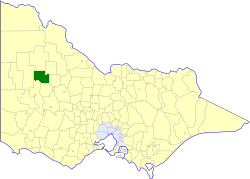
caption = Location in Victoria
county = Borung
near-nw = Dimboola
near-n = Karkarooc
near-ne = Birchip
near-w = Dimboola
near-e = Donald
near-sw = Wimmera
near-s = Dunmunkle
near-se = Donald
_noautocat = yesThe Shire of Warracknabeal was a Local Government Area located about convert|200|km|mi|0 west-northwest of Bendigo and convert|60|km|mi|0 north of Horsham in western Victoria,
Australia . The shire covered an area of convert|1839|km2|sqmi|1, and existed from 1891 until 1995.History
The Warracknabeal area was initially governed by the District of St Arnaud, first created in 1861, which became a Shire in 1864. On 30 January 1891, its West Riding was severed to create the Shire of Borung. Several boundary changes occurred between 1891 and 1916:
* 12 May 1893 - Borung annexed the East Riding of the
Shire of Dimboola , which became the West Riding.
* 22 May 1896 - Part of Borung was annexed by theShire of Birchip .
* 29 May 1896 - Borung lost part of its North and West Ridings which became theShire of Karkarooc , but gained part ofShire of Wimmera . This addition was adjusted on 9 April 1897.
* 21 May 1916 - Borung lost part of its East and South Ridings to theShire of Dunmunkle , to form that Shire's North Riding.On 7 September 1938 Borung was formally renamed Warracknabeal.cite book|title=Victorian Municipal Directory|year=1992|publisher=Arnall & Jackson|location=Brunswick|pages=884-885 Accessed at
State Library of Victoria , La Trobe Reading Room.]On 20 January 1995, the Shire was abolished, and merged with most of the Shires of Dunmunkle and
Shire of Karkarooc and parts of the Wimmera into theShire of Yarriambiack . [cite book|url=http://www.ausstats.abs.gov.au/ausstats/free.nsf/0/76E601D6DB55E88ACA25722500049195/$File/12570_1994-95.pdf|title=Victorian local government amalgamations 1994-1995: Changes to the Australian Standard Geographical Classification|author=Australian Bureau of Statistics |date=1 August 1995|publisher=Commonwealth of Australia|page=12|isbn=0-642-23117-6|accessdate=2008-01-05]Wards
Warracknabeal was divided into three ridings on 10 November 1987, each of which elected three councillors:
* North West Riding
* North East Riding
* South East RidingTowns and Localities
Population
* Estimate in the 1958 Victorian Year Book.
References
Wikimedia Foundation. 2010.