- Marmaton Township, Allen County, Kansas
-
Marmaton Township — Township — Location in Allen County
Coordinates: 37°54′25″N 095°09′36″W / 37.90694°N 95.16°WCoordinates: 37°54′25″N 095°09′36″W / 37.90694°N 95.16°W Country United States State Kansas County Allen Area – Total 55.82 sq mi (144.56 km2) – Land 55.76 sq mi (144.43 km2) – Water 0.05 sq mi (0.13 km2) 0.09% Elevation 1,099 ft (335 m) Population (2000) – Total 853 – Density 15.3/sq mi (5.9/km2) GNIS feature ID 0474522 Marmaton Township is one of twelve townships in Allen County, Kansas, USA. As of the 2000 census, its population was 853. The majority of inhabitants are farmers.
Geography
Marmaton Township covers an area of 55.82 square miles (144.6 km2) and contains one incorporated settlement, Moran. According to the USGS, it contains one cemetery, Moran.
The stream of Sweet Branch runs through this township.
References
External links
Municipalities and communities of Allen County, Kansas Cities 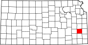
Townships Unincorporated
communitiesBayard | Carlyle | Cofachique | Geneva | Petrolia
Categories:- Townships in Allen County, Kansas
- Southeast Kansas geography stubs


Wikimedia Foundation. 2010.