Cholonge

Cholonge

Cholonge

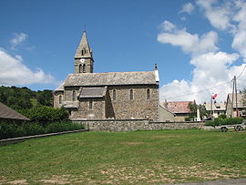
Chollonges Eglise.jpg
Vue de l'église de Cholonge
Cholonge is located in France
{{{alt}}}
Cholonge
Administration
Country France
Region Rhône-Alpes
Department Isère
Arrondissement Grenoble
Canton La Mure
Intercommunality Communauté de communes de la Matheysine
Mayor Georges Ruelle
(2001–2008)
Statistics
Elevation 905–2,140 m (2,969–7,020 ft)
Land area1 9 km2 (3.5 sq mi)
Population2 229  (1999)
 - Density 25 /km2 (65 /sq mi)
INSEE/Postal code 38106/ 38220
1 French Land Register data, which excludes lakes, ponds, glaciers > 1 km² (0.386 sq mi or 247 acres) and river estuaries.
2 Population without double counting: residents of multiple communes (e.g., students and military personnel) only counted once.

Coordinates: 45°00′18″N 5°47′51″E / 45.005°N 5.7975°E / 45.005; 5.7975

Cholonge is a commune in the Isère department in south-eastern France.

See also


Wikimedia Foundation. 2010.

Игры ⚽ Поможем сделать НИР

Look at other dictionaries:

  • Cholonge — Cholonge …   Wikipedia Español

  • Cholonge — 45° 00′ 18″ N 5° 47′ 51″ E / 45.005, 5.7975 …   Wikipédia en Français

  • Шолонж — Коммуна Шолонж Cholonge Страна ФранцияФранция …   Википедия

  • Communes of the Isère department — The following is a list of the 533 different communes of the Isère département, in France. (CUB) Agglomeration community of Grenoble Alpes Métropole, created in 2000. (CAVI) Agglomeration community of Pays Viennois, created in 2002, also partly… …   Wikipedia

  • Champ-sur-Drac — Champ sur Drac …   Wikipedia

  • Miribel-Lanchâtre — Miribel Lanchâtre …   Wikipedia

  • Méaudre — Méaudre …   Wikipedia

  • Moirans — Moirans …   Wikipedia

  • Chanas, Isère — Chanas …   Wikipedia

  • Corps, Isère — Corps …   Wikipedia

Share the article and excerpts

Direct link
Do a right-click on the link above
and select “Copy Link”