- Clohars-Carnoët
-
Clohars-Carnoët
Kloar-Karnoed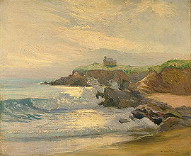
Le Pouldu, Clohars-Carnoët 
 Clohars-CarnoëtLocation within Brittany region
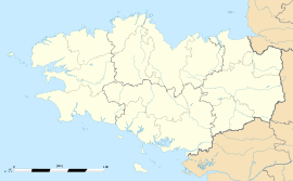 Clohars-Carnoët
Administration Country France Region Brittany Department Finistère Arrondissement Quimper Canton Quimperlé Intercommunality Pays Fouesnantais Mayor Jacques Juloux
(2008–2014)Statistics Elevation 0–71 m (0–233 ft) Land area1 34.83 km2 (13.45 sq mi) Population2 3,999 (2008) - Density 115 /km2 (300 /sq mi) INSEE/Postal code 29031/ 29360 1 French Land Register data, which excludes lakes, ponds, glaciers > 1 km² (0.386 sq mi or 247 acres) and river estuaries. 2 Population without double counting: residents of multiple communes (e.g., students and military personnel) only counted once. Coordinates: 47°47′48″N 3°35′01″W / 47.7967°N 3.5836°W
Clohars-Carnoët (Breton: Kloar-Karnoed) is a commune in the Finistère department of Brittany in north-western France.
Contents
Geography
The commune has two small harbours: Le Pouldu and Doëlan.
Population
Inhabitants of Clohars-Carnoët are called in French Cloharsiens.
Historical population of Clohars-Carnoët 1793 1800 1806 1821 1831 1836 1841 1846 1851 1856 2469 2532 2353 2725 2795 2830 2850 3146 3332 3072 1861 1866 1872 1876 1881 1886 1891 1896 1901 1906 3125 3466 3389 3480 3572 3623 3717 3771 4010 4355 1911 1921 1926 1931 1936 1946 1954 1962 1968 1975 4539 4474 4328 4287 4284 4226 3931 3919 3539 3284 1982 1990 1999 2008 3406 3678 3867 3999 See also
References
- Mayors of Finistère Association (French);
External links
- Official website (French)
Categories:- Communes of Finistère
- Finistère geography stubs


Wikimedia Foundation. 2010.