- Modesto City-County Airport
-
Modesto City-County Airport
Harry Sham Field
IATA: MOD – ICAO: KMOD – FAA LID: MOD Summary Airport type Public Operator City of Modesto Location Modesto, California Elevation AMSL 97 ft / 29.6 m Coordinates 37°37′33″N 120°57′16″W / 37.62583°N 120.95444°WCoordinates: 37°37′33″N 120°57′16″W / 37.62583°N 120.95444°W Runways Direction Length Surface ft m 10L/28R 5,911 1,802 Asphalt 10R/28L 3,459 1,054 Asphalt Modesto City-County Airport (IATA: MOD, ICAO: KMOD, FAA LID: MOD), also known as Harry Sham Field, is located two miles (3 km) southeast of the central business district (CBD) of Modesto, a city in Stanislaus County, California, USA.
Contents
History
Modesto City-County Airport (MOD) was the nation's first municipally-owned airport, opening for general aviation operation in 1918, At first the airport located southeast of downtown Modesto was only 82 acres (33 ha);and then relocated in 1929 to the current location. Over the years, it grew to its present size of 435 acres (176 ha). The airport started with only a single runway, but a second runway was added in the 1950s. During World War II, Modesto Airport was used as a military auxiliary airbase to train U.S. Air Corps pilots.
Originally, the airport was named Modesto Municipal Airport; and on May 25, 1955 when Stanislaus County and the City of Modesto became partners in the airport, the airport was renamed Modesto City-County Airport. In October 1974, Harry Sham Field was added to the name to honor the airport manager that served between 1949 and 1968.
Air carrier service was first offered to the community in 1946 when United Airlines opened its newly constructed terminal and began the Valley Queen service. Since 1946 Modesto has had continuous air service. United Airlines flew DC-3s, Convair 340s, DC-6s and B-737s until pulling out in 1979-80, after the airline industry had been deregulated. Since 1979, Modesto has had regional air carrier service to San Francisco bay area airports.
On October 12, 1991, the Modesto City Council and Stanislaus Board of Supervisors rededicated the remodeled passenger terminal that was enlarged to 8,900 square feet (830 m2). The remodeling project upgraded the building originally built by United Airlines.
In the 1990s, corporate and business aviation became the fastest growing segment of activity for the airport. Corporate jets provide their owners with convenient point-to-point service. In 2001, Modesto was the base for at least eight corporate jets.
Mid-2006 saw a change to MOD Airport. United Express/SkyWest Airlines added four flights a day to/from LAX and an additional flight to SFO to total 5 flights a day to/from San Francisco. As a result, passenger counts have continued to grow. In 2002, passenger counts averaged 3,035 per month; over the first six months of 2007, that amount has grown to an average of 7,739 passengers per month.
In June 2008, Utah based Skywest Airlines (United Express) stopped service to Los Angeles citing high fuel prices as one reason for discontinuing service. In 2007 Modesto set a record number of boarding passengers with 51,587 taking flights from the airport.
In January 2010, the airport attracted periodic leisure charter flights, operated with 130-150 passenger B737-400 and MD80 jet airliners, to Laughlin and West Wendover, NV.
Facilities
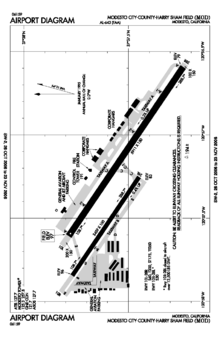
Modesto City-County Airport has two runways:
- Runway 10L/28R: 5,911 x 150 ft (1,802 x 46 m) asphalt, Pavements 60/200/400, HIRL, MALSR, PCL 9:00 p.m. - 7:00 a.m. (Freq 125.3) VASI - RW 10L.
- Runway 10R/28L: 3,459 x 100 ft (1,054 x 30 m) asphalt, Pavements 30/-/-, MIRL, not available when tower closed, PAPI - RW 10R/28L.
Airline and destinations
Airlines Destinations United Express operated by SkyWest Airlines San Francisco References
- FAA Airport Master Record for MOD (Form 5010 PDF)
- Modesto City-County Airport (official site)
External links
- FAA Airport Diagram (PDF), effective 20 October 2011
- Resources for this airport:
- AirNav airport information for KMOD
- ASN accident history for MOD
- FlightAware airport information and live flight tracker
- NOAA/NWS latest weather observations
- SkyVector aeronautical chart for KMOD
- FAA current MOD delay information
Categories:- Airports in Stanislaus County, California
- Public transportation in the San Joaquin Valley Area
- Central Valley of California
- Transportation in Modesto, California
Wikimedia Foundation. 2010.
