- Sandy Valley, Nevada
Infobox Settlement
official_name = Sandy Valley, Nevada
settlement_type = CDP
imagesize =
image_caption =
imagesize =
image_caption =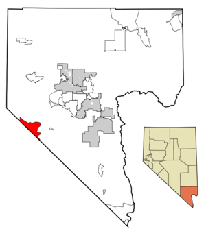
mapsize = 250px
map_caption = Location of Sandy Valley in Clark County,Nevada
mapsize1 =
map_caption1 =
image_dot_
dot_mapsize =
dot_map_caption =
dot_x =
dot_y =
subdivision_type = Country
subdivision_name =United States
subdivision_type1 = State
subdivision_name1 =Nevada
subdivision_type2 =
subdivision_name2 =
subdivision_type3 =
subdivision_name3 =
government_type =
leader_title =
leader_name =
established_title =
established_date =
area_magnitude =
unit_pref = Imperial
area_footnotes =
area_total_km2 = 145.1
area_land_km2 = 145.1
area_water_km2 = 0.0
area_total_sq_mi = 56.0
area_land_sq_mi = 56.0
area_water_sq_mi = 0.0
area_water_percent =
population_as_of = 2000
population_footnotes =
population_note =
population_total = 1804
population_density_km2 = 14.5
population_density_sq_mi = 37.4
population_blank1_title =
population_blank1 =
population_density_blank1_km2 =
population_density_blank1_sq_mi =
timezone = PST
utc_offset = -8
timezone_DST = PDT
utc_offset_DST = -7
latd = 35 |latm = 49 |lats = 44 |latNS = N
longd = 115 |longm = 39 |longs = 7 |longEW = W
elevation_footnotes =
elevation_m = 805
elevation_ft = 2641
postal_code_type =ZIP code
postal_code = 89019
area_code = 702
blank_name = FIPS code
blank_info = 32-64600
blank1_name = GNIS feature ID
blank1_info = 0854717
website =
footnotes =Sandy Valley is a
census-designated place (CDP) in the Mesquite Valley in west-central Clark County,Nevada ,United States . Sandy Valley has variant name of Sandy, Nevada. [US Geological Survey, National Geographic Names Database.] The population was 1,804 at the 2000 census. Sandy Valley is bordered on the East by the southern extension of the Spring Mountains and on the west by the California state line. Sandy Valley began in the 1800s as the five mining communities of Kingston, Sandy, Ripley, Mesquite, and Platina. It is roughly a forty-five mile drive from Las Vegas.Residents of the community have numbers in the format (702) 723-xxxx. The ZIP code for this area is 89019.
Residents of the neighboring areas of the Mesquite Valley in California have telephone numbers (760) 657-xxxx.
"Sky Ranch Estates Airport" (FAA Identifier: 3L2), is the local general aviation field. [US Department of Transportation, Federal Aviation Administration, Special Federal Aviation Regulations, SFAR number 61 to Part 91, Section 2.] The airfield is located on the Nevada side of both the Von Schmidt Line
1873 (state line) and the present-day state line. A BLM Runway runs parallel to the state line and is located between the 1873 Von Schmidt state line and the current state line. The intersection of the two runways is at coor dms|35|47|40|N|115|37|42|W. [US Geological Survey, Shenandoah Peak, Nevada, 7.5 minute quadrangle, 1985. ] On some maps the airport is incorrectly plotted near the intersection of Kingston Road and Quartz Avenue.Geography
Sandy Valley is located at coord|35|49|44|N|115|39|7|W|region:US-NV_type:city|display=inline (35.828999, -115.651943)GR|1.
According to the
United States Census Bureau , the CDP has a total area of 56.0square mile s (145.1km² ), all of it land.Demographics
As of the
census GR|2 of 2000, there were 1,804 people, 714 households, and 476 families residing in the CDP. Thepopulation density was 32.2 people per square mile (12.4/km²). There were 811 housing units at an average density of 14.5/sq mi (5.6/km²). The racial makeup of the CDP was 92.57% White, 1.39% African American, 0.61% Native American, 0.72% Asian, 0.06% Pacific Islander, 2.72% from other races, and 1.94% from two or more races. Hispanic or Latino of any race were 6.49% of the population.There were 714 households out of which 26.2% had children under the age of 18 living with them, 54.1% were married couples living together, 7.3% had a female householder with no husband present, and 33.2% were non-families. 23.8% of all households were made up of individuals and 7.8% had someone living alone who was 65 years of age or older. The average household size was 2.53 and the average family size was 3.03.
In the CDP the population was spread out with 25.1% under the age of 18, 4.0% from 18 to 24, 25.3% from 25 to 44, 33.8% from 45 to 64, and 11.9% who were 65 years of age or older. The median age was 43 years. For every 100 females there were 101.3 males. For every 100 females age 18 and over, there were 106.4 males.
The median income for a household in the CDP was $43,663, and the median income for a family was $46,389. Males had a median income of $37,000 versus $26,074 for females. The
per capita income for the CDP was $17,439. About 9.0% of families and 14.9% of the population were below thepoverty line , including 22.7% of those under age 18 and 8.7% of those age 65 or over.Education
Clark County School District serves Sandy Valley.Residents are zoned to
Sandy Valley School (K-12). [http://ccsd.net/schools/zoning/zoning.php] [" [http://ccsd.net/schools/zoning/maps/msNorth.pdf 2008-09 Middle School - Northern Attendance Boundaries] ." "Clark County School District ". AccessedSeptember 28 ,2008 .] [" [http://ccsd.net/schools/zoning/maps/hsSouth.pdf 2008-09 High School - Southern Attendance Boundaries] ." "Clark County School District ". AccessedSeptember 28 ,2008 .]References
External links
* [http://sandyvalley.us/ Information about Sandy Valley]
* [http://www.accessclarkcounty.com/depts/administrative_services/Town_Services/Pages/sandyvalleyagenmin.aspx Sandy Valley Citizens Advisory Council Meeting Agendas and Minutes]
Wikimedia Foundation. 2010.