- La Plata, Missouri
Infobox Settlement
official_name = La Plata, Missouri
settlement_type =City
nickname =
motto =
imagesize =
image_caption =
image_
imagesize =
image_caption =
image_
mapsize = 250px
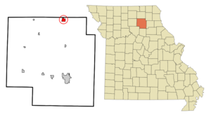
map_caption = Location of La Plata, Missouri
mapsize1 =
map_caption1 =subdivision_type = Country
subdivision_name =United States
subdivision_type1 = State
subdivision_name1 =Missouri
subdivision_type2 = County
subdivision_name2 = Macon
government_footnotes =
government_type =
leader_title =
leader_name =
leader_title1 =
leader_name1 =
established_title =
established_date =unit_pref = Imperial
area_footnotes =area_magnitude =
area_total_km2 = 3.2
area_land_km2 = 3.2
area_water_km2 = 0.0
area_total_sq_mi = 1.2
area_land_sq_mi = 1.2
area_water_sq_mi = 0.0population_as_of = 2000
population_footnotes =
population_total = 1486
population_density_km2 = 470.7
population_density_sq_mi = 1219.0timezone = Central (CST)
utc_offset = -6
timezone_DST = CDT
utc_offset_DST = -5
elevation_footnotes =
elevation_m = 285
elevation_ft = 935
latd = 40 |latm = 1 |lats = 26 |latNS = N
longd = 92 |longm = 29 |longs = 32 |longEW = Wpostal_code_type =
ZIP code
postal_code = 63549
area_code = 660
blank_name = FIPS code
blank_info = 29-40682GR|2
blank1_name = GNIS feature ID
blank1_info = 0739998GR|3
website =
footnotes =La Plata is a city in Macon County,
Missouri ,United States . The population was 1,486 at the 2000 census.Geography
La Plata is located at coor dms|40|1|26|N|92|29|32|W|city (40.024013, -92.492279)GR|1. According to the
United States Census Bureau , the city has a total area of 1.2square mile s (3.2km² ), all of it land.Demographics
As of the
census GR|2 of 2000, there were 1,486 people, 630 households, and 388 families residing in the city. Thepopulation density was 1,219.0 people per square mile (470.3/km²). There were 702 housing units at an average density of 575.9/sq mi (222.2/km²). The racial makeup of the city was 98.65% White, 0.13% African American, 0.07% Native American, 0.13% Asian, 0.27% from other races, and 0.74% from two or more races. Hispanic or Latino of any race were 1.68% of the population.There were 630 households out of which 28.6% had children under the age of 18 living with them, 48.6% were married couples living together, 10.3% had a female householder with no husband present, and 38.3% were non-families. 35.4% of all households were made up of individuals and 24.0% had someone living alone who was 65 years of age or older. The average household size was 2.28 and the average family size was 2.96.
In the city the population was spread out with 25.2% under the age of 18, 7.3% from 18 to 24, 23.8% from 25 to 44, 17.8% from 45 to 64, and 26.0% who were 65 years of age or older. The median age was 40 years. For every 100 females there were 79.7 males. For every 100 females age 18 and over, there were 74.4 males.
The median income for a household in the city was $29,583, and the median income for a family was $36,071. Males had a median income of $26,438 versus $17,880 for females. The
per capita income for the city was $19,675. About 9.0% of families and 14.1% of the population were below thepoverty line , including 21.8% of those under age 18 and 9.7% of those age 65 or over.History
On
March 17 ,1827 , Drury Davis established a trading post about a half-mile west of what would become La Plata. The town would develop as the intersection of north and south stagecoach roads. The town was surveyed by Henry O. Clark in 1855. Clark presented a plat to settlers Louis Gex, Theodore Saunders and Dr. W. W. Moore. The men accepted the plan, and named the streets surrounding the city park for themselves (Clark chose a street one block south of the square, along his father's land). The streets Moore (on the North side), Gex (pronounced jay, on the West), and Sanders (to the South) make up three sides of the square. The town prospered as a small farming center, likeKirksville 13 miles to the North.According to local tradition, the name resulted from a lottery: the townsfolk were invited to put a proposed name into a hat, and "La Plata" was the one drawn; it had been Dr. Moore's choice, under the mistaken impression that it was French for "the silver river."
The North Missouri (later known as the
Wabash Railroad ) came to town in 1867, and theSanta Fe Railroad twenty years later, passing through La Plata on its route fromChicago to Kansas City. The Wabash railroad no longer exists, but the Amtrak station is still running on the Santa Fe rail system.Transportation
*
La Plata (Amtrak station) provides passenger train service.Kirksville Regional Airport , six miles north of La Plata, provides commuter airline connector flights to larger cities and airlines.U.S. Highway 63 has been expanded to four lanes in the last decade, meaning easy highway access to larger cities like Columbia.Notable people & Events
*
Lester Dent , author, "Doc Savage" books.
* 1999 -- La Plata R-2 High School won the Missouri Class 1-A Softball Title.References
4. "Kirksville Daily Express" Sports editor.
External links
Wikimedia Foundation. 2010.


