- Pearlington, Mississippi
Infobox Settlement
official_name = Pearlington, Mississippi
settlement_type = CDP
nickname =
motto =
imagesize = 250px
image_caption = Sign welcoming visitors to Pearlington
image_
image_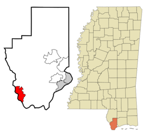
mapsize = 250px
map_caption = Location of Pearlington, Mississippi
mapsize1 =
map_caption1 =subdivision_type = Country
subdivision_name =United States
subdivision_type1 = State
subdivision_name1 =Mississippi
subdivision_type2 = County
subdivision_name2 = Hancock
government_footnotes =
government_type =
leader_title =
leader_name =
leader_title1 =
leader_name1 =
established_title =
established_date =unit_pref = Imperial
area_footnotes =area_magnitude =
area_total_km2 = 24.8
area_land_km2 = 23.6
area_water_km2 = 1.2
area_total_sq_mi = 9.6
area_land_sq_mi = 9.1
area_water_sq_mi = 0.5population_as_of = 2000
population_footnotes =
population_total = 1684
population_density_km2 = 71.4
population_density_sq_mi = 184.9timezone = Central (CST)
utc_offset = -6
timezone_DST = CDT
utc_offset_DST = -5
elevation_footnotes =
elevation_m = 3
elevation_ft = 10
latd = 30 |latm = 15 |lats = 0 |latNS = N
longd = 89 |longm = 36 |longs = 18 |longEW = Wpostal_code_type =
ZIP code
postal_code = 39572
area_code = 228
blank_name = FIPS code
blank_info = 28-55920
blank1_name = GNIS feature ID
blank1_info = 0675547
website =
footnotes =Pearlington is a
census-designated place (CDP) in Hancock County,Mississippi ,United States , on US Highway 90, along the Pearl River, at theLouisiana stateline. It is part of the Gulfport–Biloxi, Mississippi Metropolitan Statistical Area. The population was 1,684 at the 2000 census. On August 29, 2005, at 10 a.m.Hurricane Katrina made landfall just south of Pearlington (see details below).Geography
Pearlington is located at coor dms|30|14|60|N|89|36|18|W|city (30.249994, -89.604939)GR|1.
According to the
United States Census Bureau , the CDP has a total area of 9.6square mile s (24.8km² ), of which, 9.1 square miles (23.6 km²) of it is land and 0.5 square miles (1.2 km²) of it (4.91%) is water.Demographics
As of the
census GR|2 of 2000, there were 1,684 people, 648 households, and 460 families residing in the CDP. Thepopulation density was 184.9 people per square mile (71.4/km²). There were 830 housing units at an average density of 91.1/sq mi (35.2/km²). The racial makeup of the CDP was 77.55% White, 20.43% African American, 0.36% Native American, 0.12% Asian, 0.12% from other races, and 1.43% from two or more races. Hispanic or Latino of any race were 1.37% of the population.There were 648 households out of which 31.5% had children under the age of 18 living with them, 52.3% were married couples living together, 11.9% had a female householder with no husband present, and 29.0% were non-families. 23.3% of all households were made up of individuals and 9.4% had someone living alone who was 65 years of age or older. The average household size was 2.60 and the average family size was 3.08.
In the CDP the population was spread out with 25.8% under the age of 18, 7.3% from 18 to 24, 24.8% from 25 to 44, 29.1% from 45 to 64, and 12.9% who were 65 years of age or older. The median age was 40 years. For every 100 females there were 99.3 males. For every 100 females age 18 and over, there were 103.4 males.
The median income for a household in the CDP was $31,224, and the median income for a family was $36,711. Males had a median income of $32,450 versus $25,948 for females. The
per capita income for the CDP was $14,040. About 18.2% of families and 17.6% of the population were below thepoverty line , including 13.0% of those under age 18 and 22.3% of those age 65 or over.Education
Pearlington is served by the
Hancock County School District .Hurricane Katrina
On
August 29 ,2005 at 10 amCDT (1500UTC ),Hurricane Katrina made a third landfall on Pearlington. The eye of the hurricane made direct contact with Pearlington, halfway between Biloxi, and New Orleans. Hurricane Katrina came ashore during the high tide of 8:01AM, raising flood waters +2.2 feet more. ["2005 NOAA Tide Predictions: Waveland" (2005), tide on 29-Aug-2005, "NOAA", web: [http://tidesandcurrents.noaa.gov/get_predictions.shtml?year=2005&stn=0551+South+Pass&secstn=Waveland&thh=%2b3&thm=9&tlh=%2b2&tlm=49&hh=*1.28&hl=*1.28 NOAA-tide-tables] .]Hurricane Katrina damaged over 40 Mississippi libraries, gutting the Pearlington Public Library as a total loss, requiring a complete rebuild. ["Hurricane Katrina Related Damages to Public Libraries in Mississippi" (September 2005), Mississippi Library Commission, web: [http://www.ala.org/ala/cro/katrina/MSPL_Katrina_Damage.pdf ALA-Katrina] .]
Almost a year later, a member of C.O.D.R.A. (Coalition of Disaster Relief Agencies in Pearlington) noted that every home, building, and vehicle in the town of 1600 was destroyed, and a storm surge travelled 4.5 miles inland to drown what little was left under 12-20 feet of toxic stew [ "The Once-Forgotten Town of
Pearlington, MS " (journal article), Jon White, "Pearlington Recovery & Resource Center" (online journal), C.O.D.R.A (Coalition of Disaster Relief Agencies), August 23, 2006, webpage: [http://pearlington.blogspot.com/ Pearlington-CODRA] .] from the saltwater storm tide off theGulf of Mexico .According to Vicki Smith,
Associated Press writer, Pearlington was seemingly forgotten during Katrina recovery. Ten days after the hurricane more or less annihilated the tiny hamlet on the Louisiana state line, Jeff McVay and five other members of a state emergency response team fromWalton County, Florida , arrived at the request of Hancock County.The town had nothing but a place to get water, ice and military-issued meals. There was no Red Cross or shelter. The homes were heaps of debris, and trees and nail-studded boards littered the roads. The people - perhaps 600 of the 1,700 residents - were living in tents and under tarps.
Residents say that Pearlington is old and generally overlooked. It is a fairly segregated and isolated town. It has no
mayor . The only form of government is the town's local fire department, West Hancock Fire Rescue, and its head, Chief Kim Jones.McVay asked City Team of
San Jose, California , to set up a shelter, and it opened Friday night, Day 17 post-Katrina.The official web site for the Pearlington Recovery Center is www.pearlington.info
Notes
External links
* [http://edition.cnn.com/2005/US/09/20/forgotten.town.ap/index.html Article on how Pearlington, Mississippi was affected by Hurricane Katrina]
*http://operationeden.com/
*http://westhancockfirerescue.org
*http://www.pearlington.info
Wikimedia Foundation. 2010.