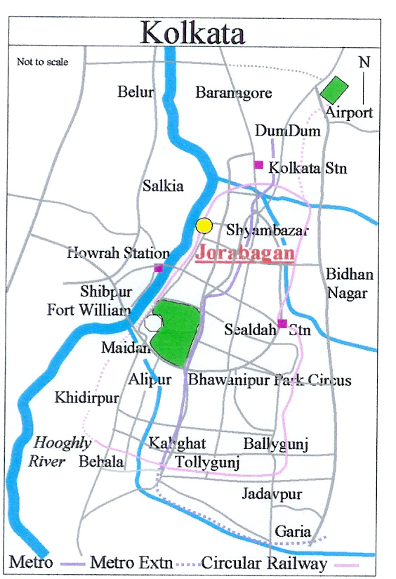
- Jorabagan
Infobox Settlement
name =PAGENAME
official_name =
other_name =
native_name =
nickname =
settlement_type =Neighbourhood in Kolkata (Calcutta)
total_type =
motto =
imagesize =
image_caption =
flag_size =
image_
seal_size =
image_shield =
shield_size =
image_blank_emblem =
blank_emblem_type =
blank_emblem_size =
mapsize = 220px
map_caption =
mapsize1 =
map_caption1 =
image_dot_
dot_mapsize =
dot_map_caption =
dot_x = |dot_y =
pushpin_
pushpin_label_position =
pushpin_map_caption =
pushpin_mapsize =
subdivision_type = Country
subdivision_name = IND
subdivision_type1 = State
subdivision_name1 =West Bengal
subdivision_type2 = City
subdivision_name2 =Kolkata
subdivision_type3 = Ward
subdivision_name3 = # 19,20,21,24,25
subdivision_type4 = Metro Station
subdivision_name4 = Girish Park
seat_type =
seat =
parts_type =
parts_style =
parts =
p1 =
p2 =
government_footnotes =
government_type =
leader_title = MLA
leader_name = Parimal Biswas
leader_title1 =
leader_name1 =
established_title =
established_date =
area_magnitude =
unit_pref =Imperial
area_footnotes =
area_total_km2 =
area_land_km2 =
area_water_km2 =
area_total_sq_mi =
area_land_sq_mi =
area_water_sq_mi =
area_water_percent =
elevation_footnotes =
elevation_m =
elevation_ft =36
elevation_max_m =
elevation_max_ft =
elevation_min_m =
elevation_min_ft =
population_as_of = 2001
population_footnotes =
population_note =
population_total = 129701
population_density_km2 =
population_density_sq_mi =
timezone = IST
utc_offset = +5:30
timezone_DST =
utc_offset_DST =
coor_type =
latd=23.8 |latm= |lats= |latNS=N
longd=88.25 |longm= |longs= |longEW=E
postal_code_type = PIN
postal_code = 700 006
area_code = +91 33
website =
footnotes =Jorabagan ( _bn. জোড়াবাগান) is a neighbourhood in north
Kolkata , earlier known as Calcutta, in theIndia n state ofWest Bengal . As a neighbourhood, it covers a small area but its importance is primarily because of the police station [cite web | url = http://www.kolkatapolice.org/Section.asp?PSID=2&Typ=PS
title = Jorabagan Police Station| accessdate = 2008-01-10 | last = | first = | work = | publisher = Kolkata Police] and the assembly constituency.Etymology
Jorabagan, meaning ‘a pair of gardens’ in Bengali, was so named because the road through it led to the garden houses of
Gobindram Mitter and Umichand. [Cotton, H.E.A., "Calcutta Old and New", 1909/1980, p 104, General Printers and Publishers Pvt. Ltd.]History
Jorabagan is part of old
Sutanuti . It is in this neighbourhood thatJob Charnock made his famous landing at Sutanuti ghat in 1690. Mohunton’s ghat between Beniatola and Sobhabazar ghats lurks the forgotten traditional landing place. There was a large tree under which Job Charnock is believed to have rested. Cotton, H.E.A., p. 282]The Sabarna Roy Choudhury Paribar Parishad, and nine other intellectuals of the city filed a public interest litigation before the
Kolkata High Court in 2001 demanding a probe into the matter whetherJob Charnock can be regarded as the founder of Kolkata. The Court, upon an Expert Committee finding, declared that Job Charnock cannot be regarded as the founder of the city. ["Bangiya Sabarna Katha Kalishetra Kalikatah" by Bhabani Roy Choudhury, Bn icon, Manna Publication. ISBN-81-87648-36-8] [http://www.devarshi.faithweb.com Sabarna Prithivi - website of the Sabarna Roy Choudhury family] ]Geography
Nimtala ghat in the neighbourhood is the burning ghat where Hindus cremate their dead. Amongst the more renowned people cremated there was
Rabindranath Tagore and the place is marked with a memorial structure. Nimtala ghat now has an electric crematorium.Demographics
Jorabagan police station area spread over ward nos. 19 (Ahiritola-Beniatola), 20 (Jorabagan, Nimtalaghat), 21 (Jorabagan – partly under North Port PS), 24 (
Pathuriaghata , Malapara), and 25 (part ofJorasanko ) had a total population of 129,701 in the 2001 census, of which 77,367 were males and 52,334 were females. The entire area recorded negative decadal growth. [cite web | url = http://www.wbcensus.gov.in/DataTables/02/Table4_17.htm
title = Provisional Population Totals, Table 4| accessdate = 2007-10-10 | last = | first = | work = Population, Decadal Growth Rate, Density and General Sex Ratio by Residence and Sex, West Bengal/ District/ Sub District, 1991 and 2001| publisher = Census Commission of India] The neighbourhood is dominated byMarwaris and is largely Hindi-speaking.Politics
In the 2006 state assembly elections the Jorabagan seat was won by Parimal Biswas of
CPI(M) defeating his nearest rival Sanjoy Bakshi of AITC. In the 2004 by-elections, Parimal Biswas of CPI(M) defeated Rajesh Kumar Sinha of INC. The bye-election was necessitated by the election of sitting MLA, Sudhansu Seal to parliament fromCalcutta North West (Lok Sabha constituency) . Sudhansu Seal of CPI(M) defeated Sanjoy Bakshi of AITC in 2001. Sanjoy Bakshi representing INC defeated Sarala Maheswari of CPI(M) in 1996. Subrata Mukherjee of INC defeated Shantilal Jain of BJP in 1991, and Sarla Maheswari of CPI(M) in 1987 and 1982. Haripada Bharati of JNP defeated Hara Prasad Chatterjee of CPI(M) in 1977. [cite web | url = http://archive.eci.gov.in/ElectionAnalysis/AE/S25/Partycomp142.htm | title = 142 - Jorabagan Assembly Constituency | accessdate = 2007-10-10 | last = | first = | work = Partywise comparison since 1977 | publisher = Election Commission of India] [cite web | url = http://pd.cpim.org/2004/1024/10242004_bengal.htm
title = Bengal LF Wins By Big Margins | accessdate = 2007-10-10 | last = | first = | work = | publisher = People’s Democracy, 24 October 2004]Jorabagan is part of
Calcutta North West (Lok Sabha constituency) [cite web | url = http://archive.eci.gov.in/se2001/background/S25/WB_ACPC.pdf | title = General election to the Legislative Assembly, 2001 – List of Parliamentary and Assembly Constituencies | accessdate = 2007-10-08 | last = | first = | work = West Bengal | publisher = Election Commission of India]References
See also
Wikimedia Foundation. 2010.
