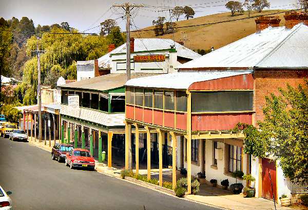
- Carcoar, New South Wales
Infobox Australian Place | type = town
name = Carcoar
state = nsw

caption = Belubula Street
lga = Blayney Shire
fedgov = Calare
postcode = 2791
est = 1839
pop = 400
elevation= 720
maxtemp = 20.9
mintemp = 6.6
rainfall = 784.6
stategov = Bathurst
dist1 = 258
location1=Sydney
dist2 = 52
location2= BathurstCarcoar is a town in the Central West region of
New South Wales ,Australia , in Blayney Shire. It has a population of almost 400. It is situated just off theMid-Western Highway 258 km west ofSydney and 52 km south-west of Bathurst and is 720 m abovesea-level . It is located in a small green valley, with the township and buildings on both banks of theBelubula River .Carcoar was once one of the most important government centres in Western New South Wales. The town has been classified by the National Trust due to the number of intact 19th-century buildings. Carcoar is a
Gundungura word meaning either "frog" or "kookaburra".Nearby towns are Blayney, Millthorpe, Mandurama, Neville, Lyndhurst and Barry.
History
ettlers
The original occupants were probably the
Gundungura Aborigines. The first European to travel through the area was surveyor George Evans, who, heading south-west from Bathurst in 1815, set up his camp at the head of Coombing Creek.The first settlers arrived in 1821. The first official land grant, comprising 560 acres (2.3 km²), was issued to Thomas Icely on 26 May 1829. He named it "
Coombing Park ". In 1838 Thomas Icely requested that a village be established to service his large pastoral estate. On 29 September 1839 Carcoar became just the third settlement west of the Blue Mountains to begazetted .The first allotments in the town were sold in 1840. By 1850 Carcoar was the second most populous town west of the mountains, second in size only to Bathurst and became a banking and administrative centre for the area. In 1857 the town's public school opened. It has continued to function as a school since that day making it one of the oldest continuous schools in Australia.
The discovery of
gold further to the west in the mid 1860s started the decline of the town. The government began erecting a number of significantpublic buildings starting in the late 1870s. At this time, "Coombing Park" was supplying iron ore to theLithgow steelworks .Railways
The location of the town in the bottom of a steep valley counted against it for railway construction. Another blow came to the town when the railway went to Blayney (13 km to the North West) in 1874. By the early 1880s the population was in decline. Carcoar was not on the rail line until 1888 when the
Blayney-Demondrille Line , which is an extension of the Main Southern Line, was constructed.In the 1980s services were suspended between Cowra and Blayney (including Carcoar). This section was re-opened by the
Lachlan Valley Railway . The LVR run tourist trains, mainly from Cowra to Blayney and Canowindra, and have now moved into general freight haulage.Convicts and bushrangers
Carcoar's population growth in the mid-1800s also brought forth problems with the local renegade
convict s andbushranger s who frequented the area and indeed ventured into the town and its surroundings on quite frequent occasion.During one event, German Charley attempting to prevent the theft of a racehorse from the "Coombing Park" stables was shot to death by Mickey Bourke. Later a bushranger by the name of Curran was captured by the local constabulary and the town was calmed by the arrival of a local magistrate and more police.
Despite or perhaps as a result of its apparent prosperity and grandeur, Carcoar continued to suffer from bushranging activity and, historically, 1863 saw what is most likely to be Australia's first daylight bank robbery when Johnny Gilbert and John O'Meally held up the Commercial Bank. The robbery was unsuccessful because both bandits fled empty-handed when a brave teller in the bank fired a shot into the ceiling of the bank, and the resulting sound alerted the township's residents.
Later still the Presbyterian Reverend James Adam was held up by
Ben Hall who finding that the Reverend made a good impression upon him decided not to rob him.Frank Gardiner , previously working in the area when he was granted a ticket of leave as a part of his parole conditions after a six year stint for horse theft, broke his parole and took up cattle thieving.Film and television
In recent years the town has been used as a location for numerous film and television productions including "Jessica" (starring
Sam Neill ), "Let the Balloon Go ", "Brides of Christ" and "Tommy the Kid".References
External links
* [http://www.nationaltrust.org.au/ National Trust of Australia]
* [http://www.firearmsmuseum.org.au/ Firearms Tech Museum]
* [http://www.lvr.com.au/ Lachlan Valley Railway]
* [http://www.tommythekid.net/ Tommy the Kid - Australian Short Film]
Wikimedia Foundation. 2010.
