Mandurama, New South Wales

Mandurama, New South Wales
Mandurama
New South Wales
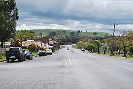
Mandurama Mid-Western Highway 002.JPG
Olive Street, the main street of Mandurama, looking north
Mandurama is located in New South Wales
{{{alt}}}
Mandurama
Population: 379[1]
Established: 1839
Postcode: 2792
Coordinates: 33°39′S 149°05′E / 33.65°S 149.083°E / -33.65; 149.083Coordinates: 33°39′S 149°05′E / 33.65°S 149.083°E / -33.65; 149.083
Location:
LGA: Blayney Shire
State District: Burrinjuck
Federal Division: Calare

Mandurama is a village in the Blayney Shire, New South Wales, Australia. The site of the village and surrounding areas was home to the Wiradjuri people prior to settlement, and the name "Mandurama" is derived from their word for 'water holes'.[2] Mandurama is situated 259 kilometres west of Sydney, 59 kilometres southwest of Bathurst, and 47 kilometres northeast of Cowra on the Mid-Western Highway. Established in 1876 as a privately owned village for the workers of Thomas Icely's Coombing Park, it has since developed, along with nearby Lyndhurst into a modest service centre for the surrounding localities and farmland.

The village's population is small, approximately numbering around 300, but is still home to a number of amenities, including a; general store and cafe; service station; Rural Fire Service station; primary school; number of churches; golf club; tennis court; hall, and; hotel. The village also retains a number of historic buildings, including two former bank premises, a former primary school, the Lincoln Theatre, and the Belubula Lodge.

Mandurama was also the central subject of the group of photographs known as the Mandurama Collection, now housed at the National Library of Australia.

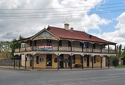
Royal Hotel at the north end of the village

See also

References


Wikimedia Foundation. 2010.

Игры ⚽ Нужен реферат?

Look at other dictionaries:

  • Neville, New South Wales — Neville is a small village in the south east of New South Wales, Australia, in Blayney Shire. It is 60km south of Bathurst or about 16 km south east of Mandurama. It is 940 metres above sea level and currently has a population of about 100.… …   Wikipedia

  • Millthorpe, New South Wales — Millthorpe New South Wales Main Street of Millthorpe …   Wikipedia

  • Newbridge, New South Wales — Newbridge is a village of about 100 residents in New South Wales, Australia in Blayney Shire. It is approximately 30 km from Bathurst and 15 km from Blayney in the Central Tablelands of NSW. At the 2006 census, Newbridge had a… …   Wikipedia

  • Carcoar, New South Wales — Infobox Australian Place | type = town name = Carcoar state = nsw caption = Belubula Street lga = Blayney Shire fedgov = Calare postcode = 2791 est = 1839 pop = 400 elevation= 720 maxtemp = 20.9 mintemp = 6.6 rainfall = 784.6 stategov = Bathurst… …   Wikipedia

  • Lyndhurst, New South Wales — Infobox Australian Place | type = town name = Lyndhurst state = nsw caption = Lyndhurst with Royal Hotel in the background lga = Blayney Shire fedgov = Calare postcode = 2797 est = pop = elevation= maxtemp = mintemp = rainfall = stategov =… …   Wikipedia

  • Barry, New South Wales — Barry is a small village in the Central West region of New South Wales, Australia, in Blayney Shire. It is situated within an hours driving time from the townships and villages of Blayney, Millthorpe, Mandurama, Neville, Lyndhurst and Carcoar.… …   Wikipedia

  • Mandurama Collection — The Mandurama Collection is a collection of 3,444 photographs from between 1865 and 1935, they were taken by photographer Evan Lumme.[1] The collection of photographs were taken in the Central Tablelands of New South Wales, most are of the… …   Wikipedia

  • Death of Dean Shillingsworth — The body of Dean Shillingsworth (25 February 2005 – 11 October 2007) [1] was discovered by children in a pond in Mandurama Reserve at Ambarvale, New South Wales, Australia on 17 October 2007. The body was inside a tartan suitcase and was badly… …   Wikipedia

  • Electoral district of Burrinjuck — Burrinjuck is an electoral district of the Legislative Assembly in the Australian state of New South Wales. It is represented by Katrina Hodgkinson of the National Party of Australia.The 2004 redistribution of electoral districts estimated that… …   Wikipedia

  • Blayney Shire — Shire of Blayney Lage des Blayney Shire in New South Wales Gliederung …   Deutsch Wikipedia

Share the article and excerpts

Direct link
Do a right-click on the link above
and select “Copy Link”