- Chickamaw Beach, Minnesota
-
Chickamaw Beach, Minnesota — City — Location of Chickamaw Beach, Minnesota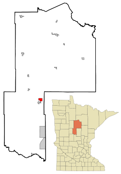
Coordinates: 46°44′33″N 94°23′59″W / 46.7425°N 94.39972°W Country United States State Minnesota County Cass Area - Total 2.6 sq mi (6.6 km2) - Land 2.2 sq mi (5.7 km2) - Water 0.4 sq mi (1.0 km2) Elevation 1,302 ft (397 m) Population (2010)[1] - Total 114 - Density 51.8/sq mi (20.0/km2) Time zone Central (CST) (UTC-6) - Summer (DST) CDT (UTC-5) FIPS code 27-11296[2] GNIS feature ID 0641152[3] Chickamaw Beach is a city in Cass County, Minnesota, United States. The population was 114 at the 2010 census.[1] It is part of the Brainerd Micropolitan Statistical Area.
Geography
According to the United States Census Bureau, the city has a total area of 2.6 square miles (6.7 km2), of which, 2.2 square miles (5.7 km2) of it is land and 0.4 square miles (1.0 km2) of it (14.45%) is water.
Minnesota State Highway 84 serves as a main route in the community. Minnesota State Highway 371 is nearby.
Demographics
As of the census[2] of 2000, there were 148 people, 63 households, and 45 families residing in the city. The population density was 67.7 people per square mile (26.1/km²). There were 110 housing units at an average density of 50.3 per square mile (19.4/km²). The racial makeup of the city was 100.00% White.
There were 63 households out of which 23.8% had children under the age of 18 living with them, 71.4% were married couples living together, 1.6% had a female householder with no husband present, and 27.0% were non-families. 22.2% of all households were made up of individuals and 11.1% had someone living alone who was 65 years of age or older. The average household size was 2.35 and the average family size was 2.78.
In the city the population was spread out with 18.2% under the age of 18, 4.7% from 18 to 24, 14.2% from 25 to 44, 39.9% from 45 to 64, and 23.0% who were 65 years of age or older. The median age was 50 years. For every 100 females there were 102.7 males. For every 100 females age 18 and over, there were 98.4 males.
The median income for a household in the city was $28,750, and the median income for a family was $43,750. Males had a median income of $27,250 versus $16,071 for females. The per capita income for the city was $20,223. There were 2.6% of families and 5.4% of the population living below the poverty line, including no under eighteens and 16.7% of those over 64.
References
- ^ a b "2010 Census Redistricting Data (Public Law 94-171) Summary File". American FactFinder. U.S. Census Bureau, 2010 Census. http://factfinder2.census.gov/faces/tableservices/jsf/pages/productview.xhtml?pid=DEC_10_PL_GCTPL2.ST13&prodType=table. Retrieved 23 April 2011.
- ^ a b "American FactFinder". United States Census Bureau. http://factfinder.census.gov. Retrieved 2008-01-31.
- ^ "US Board on Geographic Names". United States Geological Survey. 2007-10-25. http://geonames.usgs.gov. Retrieved 2008-01-31.
Municipalities and communities of Cass County, Minnesota Cities Backus | Bena | Boy River | Cass Lake | Chickamaw Beach | East Gull Lake | Federal Dam | Hackensack | Lake Shore | Longville | Motley‡ | Pillager | Pine River | Remer | Walker
Townships Ansel | Barclay | Becker | Beulah | Birch Lake | Blind Lake | Boy Lake | Boy River | Bull Moose | Bungo | Byron | Crooked Lake | Deerfield | Fairview | Gould | Hiram | Home Brook | Inguadona | Kego | Leech Lake | Lima | Loon Lake | Maple | May | McKinley | Meadow Brook | Moose Lake | Otter Tail Peninsula | Pike Bay | Pine Lake | Pine River | Ponto Lake | Poplar | Powers | Remer | Rogers | Salem | Shingobee | Slater | Smoky Hollow | Sylvan | Thunder Lake | Torrey | Trelipe | Turtle Lake | Wabedo | Walden | Wilkinson | Wilson | Woodrow
Unorganized
territoriesUnincorporated
communitiesIndian
reservationFootnotes ‡This populated place also has portions in an adjacent county or counties
Coordinates: 46°44′37″N 94°23′07″W / 46.74361°N 94.38528°W
Categories:- Populated places in Cass County, Minnesota
- Cities in Minnesota
- Brainerd micropolitan area


Wikimedia Foundation. 2010.