- Ostheim
-
For the town in France, see Ostheim, Haut-Rhin.
Ostheim 

 OstheimLocation of the town of Ostheim within Rhön-Grabfeld district
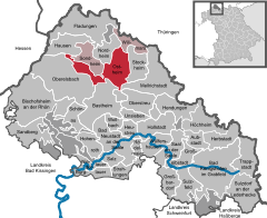
Coordinates 50°28′N 10°13′E / 50.46667°N 10.21667°ECoordinates: 50°28′N 10°13′E / 50.46667°N 10.21667°E Administration Country Germany State Bavaria Admin. region Lower Franconia District Rhön-Grabfeld Municipal assoc. Ostheim vor der Rhön Mayor Adolf Büttner (CSU) Basic statistics Area 40.73 km2 (15.73 sq mi) Elevation 300 m (984 ft) Population 3,506 (31 December 2010)[1] - Density 86 /km2 (223 /sq mi) Other information Time zone CET/CEST (UTC+1/+2) Licence plate NES Postal code 97645 Area code 09777 Website www.ostheim-vgem.de Ostheim vor der Rhön is a town situated in Bavaria (although historically part of Thuringia), in the district of Rhön-Grabfeld.
Contents
History
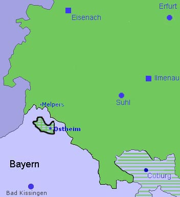
Ostheim was first mentioned in 804. Previously an exclave of Saxe-Weimar-Eisenach, Ostheim vor der Rhön was an exclave of Thuringia in Bavaria from 1920 until 1947. In 1945 Ostheim became part of the American controlled zone, in the Free State of Bavaria. In 1972, the Evangelical (Lutheran) church administration of Ostheim was switched to Bavaria from Thuringia. The Catholic administration switched from the Diocese of Fulda (Hesse) to the Diocese of Würzburg (Bavaria) in 1945.
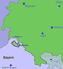 Map showing the enclave/exclave relationship
Ostheim is one of the stops in Wim Wenders' 1976 road trip film Kings of the Road.
It is also the home of German soft drink manufacturer Bionade.
Landmarks
- Church tower
- Light tower with guest hall
- Historic Old Town with mills and half-timbered houses
- Organ museum in Hanstein (with musical guidance when desired)
- Hill Graves
References
- ^ "Fortschreibung des Bevölkerungsstandes" (in German). Bayerisches Landesamt für Statistik und Datenverarbeitung. 31 December 2010. https://www.statistikdaten.bayern.de/genesis/online?language=de&sequenz=tabelleErgebnis&selectionname=12411-009r&sachmerkmal=QUASTI&sachschluessel=SQUART04&startjahr=2010&endjahr=2010.
External links
- Friendly end of political enclave in 1947 (German)
- Sonntags Blatt 1972 church enclave switch
- Ostheim vor der Rhön travel guide on Wikivoyage
Aubstadt | Bad Königshofen | Bad Neustadt | Bastheim | Bischofsheim an der Rhön | Burglauer | Fladungen | Großbardorf | Großeibstadt | Hausen | Hendungen | Herbstadt | Heustreu | Höchheim | Hohenroth | Hollstadt | Mellrichstadt | Niederlauer | Nordheim vor der Rhön | Oberelsbach | Oberstreu | Ostheim | Rödelmaier | Saal an der Saale | Salz | Sandberg | Schönau an der Brend | Sondheim | Stockheim | Strahlungen | Sulzdorf | Sulzfeld | Trappstadt | Unsleben | Willmars | Wollbach | Wülfershausen Categories:
- Towns in Bavaria
- Exclaves
- Rhön-Grabfeld
- Rhön Mountains


Wikimedia Foundation. 2010.