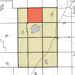
- Clear Creek Township, Huntington County, Indiana
-
Clear Creek Township — Township — Location in Huntington County Coordinates: 40°57′28″N 85°30′45″W / 40.95778°N 85.5125°WCoordinates: 40°57′28″N 85°30′45″W / 40.95778°N 85.5125°W Country United States State Indiana County Huntington Government - Type Indiana township Area - Total 35.86 sq mi (92.88 km2) - Land 35.84 sq mi (92.83 km2) - Water 0.02 sq mi (0.05 km2) 0.05% Elevation 817 ft (249 m) Population (2000) - Total 1,742 - Density 48.6/sq mi (18.8/km2) GNIS feature ID 0453221 Clear Creek Township is one of twelve townships in Huntington County, Indiana, USA. As of the 2000 census, its population was 1,742.[1]
Contents
Geography
Clear Creek Township covers an area of 35.86 square miles (92.9 km2); of this, 0.02 square miles (0.052 km2) or 0.05 percent is water. The stream of Flint Creek runs through this township.
Unincorporated towns
Adjacent townships
- Washington Township, Whitley County (north)
- Jefferson Township, Whitley County (northeast)
- Jackson Township (east)
- Union Township (southeast)
- Huntington Township (south)
- Dallas Township (southwest)
- Warren Township (west)
- Cleveland Township, Whitley County (northwest)
Major highways
References
- "Clear Creek Township, Huntington County, Indiana". Geographic Names Information System, U.S. Geological Survey. http://geonames.usgs.gov/pls/gnispublic/f?p=gnispq:3:::NO::P3_FID:0453221. Retrieved 2009-09-24.
- United States Census Bureau cartographic boundary files
External links
Municipalities and communities of Huntington County, Indiana City Towns Andrews | Markle‡ | Mount Etna | Roanoke | Warren
Townships Unincorporated
communitiesBanquo | Bippus | Bowerstown | Bracken | Buckeye | Goblesville | Harlansburg | Lancaster | Mahon | Majenica | Makin | Mardenis | Milo | Pleasant Plain | Plum Tree | Roanoke Station | Simpson
Footnotes ‡This populated place also has portions in an adjacent county or counties
Categories:- Townships in Huntington County, Indiana
Wikimedia Foundation. 2010.

