- Noordoostpolder
-
Noordoostpolder — Municipality — 
Flag
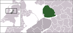
Coat of armsLocation of the Noordoostpolder in Flevoland, Netherlands Coordinates: 52°42′N 5°45′E / 52.7°N 5.75°ECoordinates: 52°42′N 5°45′E / 52.7°N 5.75°E Country Netherlands Province Flevoland Area(2007) - Total 596.20 km2 (230.2 sq mi) - Land 460.80 km2 (177.9 sq mi) - Water 135.40 km2 (52.3 sq mi) Population (1 June, 2007) - Total 45,781 - Density 99/km2 (256.4/sq mi) Source: CBS, Statline. Time zone CET (UTC+1) - Summer (DST) CEST (UTC+2) Noordoostpolder (
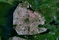
 pronunciation (help·info)) (English: North-East Polder) is a municipality in the Flevoland province in the central Netherlands. Formerly, it was also called Urker Land. Emmeloord is the administrative center, located in the heart of the Noordoostpolder. The municipality has the largest land area in the Netherlands. (Lelystad and Terschelling both technically have more total area, but in both cases it is mostly water area.)
For history see Zuiderzee Works.
Contents
Population centres
Bant, Creil, Emmeloord, Ens, Espel, Kraggenburg, Luttelgeest, Marknesse, Nagele, Rutten, and Tollebeek.
The former island of Schokland, is now a museum.
The former island of Urk, in the southwest, now surrounded by the Noordoostpolder, is a separate municipality.
Rail Links
There are no railway stations on the Noordoostpolder, but the nearest stations are in Kampen, Steenwijk and Lelystad.
UNESCO World Heritage sites
UNESCO World Heritage sites located in/near the Noordoostpolder:
- Schokland and Surroundings (municipality Noordoostpolder)
- Ir.D.F. Woudagemaal (D.F. Wouda Steam Pumping Station), Lemmer (mun. Lemsterland)
External links

See also: Netherlands · Provinces · Municipalities Categories:- Cultural Sites on the UNESCO World Heritage Tentative List
- Municipalities of Flevoland
- Zuiderzee Works
- Polders
Wikimedia Foundation. 2010.


