- Dronten
-
Dronten — Municipality — Train station of Dronten under construction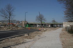

Flag
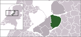
Coat of armsLocation of Dronten in Flevoland and Netherlands
Coordinates: 52°32′N 5°43′E / 52.533°N 5.717°E Country Netherlands Province Flevoland Area(2006) - Total 423.86 km2 (163.7 sq mi) - Land 334.35 km2 (129.1 sq mi) - Water 89.51 km2 (34.6 sq mi) Population (1 December, 2009) - Total 39,787 - Density 114/km2 (295.3/sq mi) Source: GBA gemeente Dronten. Time zone CET (UTC+1) - Summer (DST) CEST (UTC+2) Dronten (
 pronunciation (help·info)) is a municipality and a town in the central Netherlands. Its population is 39,787 (1 December 2009).
Contents
Population centers
- Biddinghuizen
- Dronten
- Swifterbant
History
Plans for the municipality of Dronten were made in the early half of the 1950s; real plans for the town of Dronten (the municipality's center) were revealed in 1958.
The foundations for the town were laid in 1960. Right from the start there was a discussion whether Dronten was to become a town or a city. The first plans assumed 15,000 inhabitants, while later plans foresaw a growth to 30,000 inhabitants. The first plans for the municipality assumed ten smaller villages situated around the central town (in this case Dronten). The number of villages was reduced due to increased traffic and experiences gained in developing the Noordoostpolder, where a similar municipality had already been built. Eventually it was decided there were to be two smaller villages (Biddinghuizen and Swifterbant) and one larger town (Dronten).
On 1 January 1972 Dronten was given its official name.
In 1995, Dronten hosted the 18th World Scout Jamboree. 28,960 Scouts and staff members from 166 countries and territories participated this event.
Transportation
From 2012 there will be a station in Dronten - Dronten, which will be on the railway line, linking Zwolle and Lelystad.
At the moment, Kampen railway station is closest, and easiest to park at, but for Amsterdam or Amsterdam Airport Schiphol it is recommended to travel to Lelystad Centrum railway station.
Entertainment
Biddinghuizen contains the theme park Walibi Holland.
External links
Almere · Dronten · Lelystad · Noordoostpolder · Urk · Zeewolde

See also: Netherlands · Provinces · Municipalities Coordinates: 52°32′N 5°43′E / 52.533°N 5.717°E
Categories:- Municipalities of Flevoland
- Populated places in Flevoland
- Netherlands geography stubs


Wikimedia Foundation. 2010.