- Emmeloord
Infobox Settlement
name = Emmeloord
imagesize = 250px
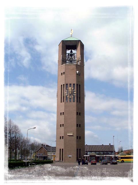
image_caption = The Poldertoren in Emmeloord
flag_size = 115px
image_shield =
shield_size = 115px
mapsize = 250px
map_caption =subdivision_type = Country
subdivision_name = flagicon|NetherlandsKingdom of the Netherlands
subdivision_type1 = Constituent country
subdivision_name1 = NLD
subdivision_type2 = Province
subdivision_name2 = flag|Flevolandpopulation_as_of =
1 January 2006
population_footnotes =
population_note =
population_total =24.866
population_density_km2 =
population_density_sq_mi =timezone =
utc_offset =
timezone_DST =
utc_offset_DST =
coor_type =
latd=52 |latm=42 |lats=35 |latNS=N
longd=5 |longm=45 |longs=3 |longEW=Epostal_code_type =
postal_code =
area_code =
website =
footnotes =Emmeloord is the administrative center of the municipality of
Noordoostpolder ,Flevoland ,Netherlands .At the heart of the
Noordoostpolder , where the three main drainage canals intersect, is the city of Emmeloord (1943 ). Emmeloord is in apolder : land reclaimed from theIJsselmeer , which earlier was part of the sea. Planned from the outset to be the first and the only major town of the polder, it is the local governmental and services centre. Ten smaller villages, conceived more as agricultural communities, were planned in a wide circle around Emmeloord, with the distances between them determined to be easily reachable bybicycle . The first settlements wereEns ,Marknesse andKraggenburg (1949 ), thenBant (1951 ), thenCreil andRutten (1953 ), and finallyEspel ,Tollebeek andNagele (1956 ). There is another village calledLuttelgeest (located northeast in the Noordoostpolder). From Emmeloord three canals take their water to three pumping stations, the "Buma" nearLemmer , the "Smeenge" atVollenhove and the "Vissering" onUrk .Emmeloord was named after an abandoned village on the island of
Schokland .In the center of Emmeloord there is a watertower called the
Poldertoren . The tower is the central point of the Noordoostpolder and could be seen from almost every location in the early years of the Noordoostpolder, when there were no tall trees. In Japan there is a [http://www.noordoostpolder.nl/content.jsp?objectid=18285 replica] of this watertower.For history see
Zuiderzee Works .External links
*http://www.emmeloord.info/ (Dutch)
*http://www.noordoostpolder.nl/ (Dutch)
Wikimedia Foundation. 2010.