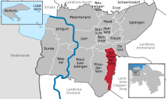
- Ostrhauderfehn
-
Ostrhauderfehn 
Coordinates 53°07′N 7°37′E / 53.11667°N 7.61667°ECoordinates: 53°07′N 7°37′E / 53.11667°N 7.61667°E Administration Country Germany State Lower Saxony District Leer Mayor Günter Harders (Ind.) Basic statistics Area 51.00 km2 (19.69 sq mi) Elevation 3 m (10 ft) Population 10,658 (31 December 2010)[1] - Density 209 /km2 (541 /sq mi) Other information Time zone CET/CEST (UTC+1/+2) Licence plate LER Postal code 26842 Area codes 0 49 52 Website www.ostrhauderfehn.de Ostrhauderfehn is a municipality in the Leer district of Lower Saxony, Germany.
It split from Rhauderfehn sometime between 1820 and 1830. Ostrhauderfehn was for many years one of the largest municipalities in the district of Leer.
Borkum | Brinkum | Bunde | Detern | Filsum | Firrel | Hesel | Holtland | Jemgum | Leer | Moormerland | Neukamperfehn | Nortmoor | Ostrhauderfehn | Rhauderfehn | Schwerinsdorf | Uplengen | Weener | WestoverledingenReferences
- ^ "Bevölkerungsfortschreibung" (in German). Landesbetrieb für Statistik und Kommunikationstechnologie Niedersachsen. 31 December 2009. http://www1.nls.niedersachsen.de/statistik/html/parametereingabe.asp?DT=K1000014&CM=Bev%F6lkerungsfortschreibung.
Categories:- Municipalities in Lower Saxony
- Weser-Ems region geography stubs
- Towns and villages in East Frisia
Wikimedia Foundation. 2010.


