Penshurst, Victoria

Penshurst, Victoria

Infobox Australian Place | type = town
name = Penshurst
state = vic


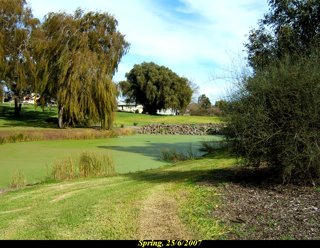
caption = Spring at the Penshurst botanical gardens
lga = Shire of Southern Grampians
postcode = 3289
coordinates = coord|37.8751|S|142.2905|E|display=inline,title|region:AU-VIC_type:city
est =
pop = 487
elevation=
maxtemp =
mintemp =
rainfall =
stategov = Lowan
fedgov = Wannon
dist1 = 279
dir1 = W
location1= Melbourne
dist2 = 31
dir2 = SE
location2= Hamilton
dist3 = 42
dir3 = NW
location3= Hexham

Penshurst is a town in Victoria, Australia. It is in the Shire of Southern Grampians local government area and is located at the foot of Mt Rouse, an extinct volcano. At the 2001 census, Penshurst had a population of 487.Census 2001 AUS
id=UCL241600
name=Penshurst (L) (Urban Centre/Locality)
accessdate=2007-08-05
quick=on
] Basic facilities include a hospital with an aged care residency and doctor's surgery, a pub, a post office, a newsagent, a grocery store, a hall and two schools – one a state school, the other a Catholic school – the state school has approximately six children, the Catholic school about 30.

The town was settled in the 1850s, the Post Office opening on September 1, 1857 Citation

last = Premier Postal History | title = Post Office List | url = https://www.premierpostal.com/cgi-bin/wsProd.sh/Viewpocdwrapper.p?SortBy=VIC&country= | access-date = 2008-04-11 ]

Penshurst is located in an area littered with basalt stones up 2m long from the Mt Rouse volcano. These are know locally as the stony rises. The north east side of Mt Rouse is used as a quarry and crushed for road making scoria.

There were instances in the 1970’s where bushfires triggered peat fires beneath the stony rises which burnt for a number on months. A fire watch building is located at the top of Mt Rouse.

Penshurst is serviced by a fresh water spring located in the town and has many historic shops.

The Penshurst racecourse hosts one racing calendar event each year on Boxing Day and is located about 1km north of Bell Street (the Main Street).

The town has an Australian Rules football team competing in the Mininera & District Football League.

References


Wikimedia Foundation. 2010.

Игры ⚽ Поможем сделать НИР

Look at other dictionaries:

  • Penshurst (disambiguation) — Penshurst is the name of a village in Kent, England.Penshurst may also refer to: *Penshurst Place, a historic building in that village *Penshurst, New South Wales, a suburb of Sydney, Australia *Penshurst, Victoria, a town in Australia …   Wikipedia

  • Penshurst — steht für Penshurst (Kent), England. Penshurst Place, historisches Bauwerk daselbst Penshurst (New South Wales), Sydney, Australien Penshurst (Victoria), Australien Diese Seite ist eine Begriffsklärung zur Unterscheidung meh …   Deutsch Wikipedia

  • List of localities in Victoria (Australia) — Map of Local Government Areas in Victoria This is a list of locality names and populated place names in the state of Victoria, Australia, outside the Melbourne metropolitan area. It is organised by region from the south west of the state to the… …   Wikipedia

  • Liste der Orte in Victoria — Dies ist eine Liste der Vororte und Orte von Melbourne und des australischen Bundesstaats Victoria mit ihrem jeweils zugehörigen Postcode (Einige Vororte teilen den gleichen Postcode). Alle Postcodes Victorias beginnen mit 3 . Inhaltsverzeichnis… …   Deutsch Wikipedia

  • Dunkeld, Victoria — Dunkeld Victoria The Royal Mail Hotel with the Grampians in the background …   Wikipedia

  • Port Fairy railway line, Victoria — VictorianRailwayLineInfobox type = vic name = Port Fairy yearcommenced = yearopened = 1857 yearcompleted = 1890 yearclosed = fate = lengthkm = stations = tracks = Double broad gauge track to Geelong, single beyond. Single standard gauge to North… …   Wikipedia

  • Hawkesdale, Victoria — Infobox Australian Place | type = town name = Hawkesdale state = vic caption = lga = Shire of Moyne postcode = 3287 est = pop = 399 elevation= maxtemp = mintemp = rainfall = stategov = Polwarth fedgov = Wannon dist1 = dir1 = location1= dist2 =… …   Wikipedia

  • Coleraine, Victoria — Coleraine Victoria View of town from Peter Francis Points Arboretum …   Wikipedia

  • County of Dundas, Victoria — Dundas Victoria Lands administrative divisions around Dundas Lowan Lowan Borung …   Wikipedia

  • Liste der Orte in Victoria (Australien) — Dies ist eine Liste der Vororte und Orte von Melbourne und des australischen Bundesstaats Victoria mit ihrem jeweils zugehörigen Postcode (Einige Vororte teilen den gleichen Postcode). Alle Postcodes Victorias beginnen mit 3 . Inhaltsverzeichnis… …   Deutsch Wikipedia

Share the article and excerpts

Direct link
Do a right-click on the link above
and select “Copy Link”