- California State Route 275
Infobox road
state=CA
type=SR
route=275
maint=Caltrans 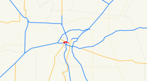
length_mi=2.074
length_round=3
length_ref=
length_notes=(before 2001 and 2006 relinquishments)
history=State highway in 1910; became US 40/99W in 1928-29, I-80 in 1964, and SR 275 in 1967
direction_a=West
terminus_a=jct|state=CA|BL|80|dab1=Sacramento in West Sacramento
junction=Riske Lane in West Sacramento----River Road in West Sacramento
direction_b=East
terminus_b=Front Street in Sacramento
previous_type=SR
previous_route=273
next_type=I
next_route=280State Route 275 (SR 275) is a short unsigned
state highway in the Sacramento area of theU.S. state ofCalifornia . The highway, also known as Tower Bridge Gateway (formerly West Sacramento Freeway), is a short spur from Interstate 80 Business in West Sacramento over the Tower Bridge intodowntown Sacramento . Despite its deletion from the Streets and Highways Code in 1996, theCalifornia Department of Transportation (Caltrans) still maintains about half of the route; approximately 1/2 mile (1 km) was relinquished to West Sacramento in 2001 and about the same (alongCapitol Mall ) to Sacramento in 2006. (Similarly, State Route 160 is still a state highway north of theAmerican River in Sacramento, but the legislative description ends at the south city limits.) West Sacramento has begun a project to replace the freeway with apedestrian-friendly street.Route description
The West Sacramento Freeway begins on Interstate 80 at exit 81 (West Capitol Avenue), the east end of the
Yolo Causeway . It soon splits, with I-80 exiting to bypass Sacramento to the north and Interstate 80 Business (legislatively U.S. Route 50) continuing east via exit 82 towards downtown. After one interchange, at Harbor Boulevard (exit 1/1B), the freeway splits again, with Bus. 80 turning abruptly southeast over the Pioneer Memorial Bridge to avoid downtown Sacramento. State Route 275 begins here, at exit 3 of Bus. 80, with full access to and from the intersecting Jefferson Boulevard (State Route 84).Google Maps street maps andUSGS topographic map s, accessed December 2007 via [http://mapper.acme.com/ ACME Mapper] ]State maintenance ends just after the Jefferson Boulevard interchange, and the road — now maintained by the city of West Sacramento as Tower Bridge Gateway — crosses the future Garden Street at grade. This intersection replaced a partial
trumpet interchange , oriented towards West Capitol Avenue with a missing westbound entrance, in 2007. After Tower Bridge Gateway crosses under theUnion Pacific Railroad line that used to cross the Tower Bridge, a ramp enters the westbound lanes from the intersection of West Capitol Avenue and Fifth Street; this completed the former interchange at Riske Lane. Two blocks to the east, a westbound offramp leads to West Capitol Avenue and Third Street, and eastbound access to Broderick to the north and the formerly industrial area to the south, now containingRaley Field , is provided via South River Road.State maintenance resumes once again as SR 275 crosses the
Sacramento River on the Tower Bridge, a four-lanelift bridge that formerly carried aSacramento Northern Railroad track in the center. At the east end of the bridge, the roadway becomesCapitol Mall , maintained by the city of Sacramento, and crosses over Interstate 5. Seven blocks later, the main road ends at Ninth Street; the last block of Capitol Mall to Tenth Street, on which the State Capitol fronts, is a two-lane road with a mid-blocktraffic circle around afountain .History
SR 275 began as part of Legislative Route 6, one of the shorter main routes of the initial system funded by the 1910 bond issue. This highway, which included the several-mile-long
Yolo Causeway , connected Sacramento with the north-south Route 7 at Davis, thereby linking the capital city with theSan Francisco Bay Area . Route 6 traffic initially left Sacramento on the 1911I Street Bridge , heading southwest through the small settlement of , Sacramento Bridge to Open Dec. 15, November 17, 1935]U.S. Routes 40 and 99 (soon 99W) were marked along Route 6 in 1928. [
California Highways and Public Works , [http://www.gbcnet.com/ushighways/history/1928_highways.html United States Numbered Highways] , January 1928] These two routes remained on West Capitol Avenue [Division of Highways, [http://www.americanroads.us/citymaps/1944CaStateMapSacramento.pngSacramento] , 1944] until 1954, when the new West Sacramento Freeway opened, connecting the west end of the Tower Bridge with the east end of the Yolo Causeway.Traveler-oriented business es along the bypassed West Capitol Avenue were hit hard by the shifting of through traffic. [ [http://www.jlmintier.com/westsac/pdf/WSGPU_Background.pdf City of West Sacramento General Plan: Background Document] , revised and adopted June 14, 2000, pp. II-24, VII-14]The entire freeway was designated as part of Interstate 80 in the late 1950s. However, two bypasses were planned — a realignment of Route 6 that would take I-80 over a new bridge and around the south side of downtown, and a northern bypass of the entire city (I-880). [Division of Highways, [http://cahighways.org/maps/1963sac.jpgSacramento] , 1963] Since the southerly bypass had not been completed in time for the 1964 renumbering, the route over the Tower Bridge — and along downtown streets — became Route 80, [Division of Highways, [http://books.google.com/books?id=TFMxjh5hmxoC&q=%2215th+Street+at+Capitol+&pgis=1#search Annual Traffic Census] , 1965, p. 70 (Route 80)] but US 99W signage remained (initially following Capitol Mall to near the State Capitol, later turning south onto Third and Fifth Streets east of the bridge) [.
Normally, upon completion of the new I-80 south of downtown, the old alignment over the Tower Bridge and through downtown would be relinquished. The legislature recognized that it might be useful to keep a state highway to the Capitol, and so in 1966 it passed a
concurrent resolution requesting that theCalifornia Highway Commission delay relinquishment west of Ninth Street until the last day of the 1967 legislative session. [cite CAstat|year=1966|ex=1|res=yes|ch=94|p=872] During that session, a new Route 275 was created from that portion of former Route 80. This consisted of the eastern part of the West Sacramento Freeway, the Tower Bridge, andCapitol Mall up to Ninth Street, just west of the capitol building. The portion in Sacramento, east of the bridge, was not to be beautified with state highway funds. [cite CAstat|year=1967|ch=1350|p=3183] Due to the cancellation of a replacement of theNorth Sacramento Freeway , I-80 was moved to former I-880 around the city in 1981, giving the West Sacramento Freeway three numbers: I-80, US 50, and SR 275. [cite CAstat|year=1981|ch=292|p=1419]In 1993, the West Sacramento City Council approved the "Triangle Specific Plan" for a new downtown in the triangle bounded by the Sacramento River, SR 275, and US 50; [
] The state legislature passed a law in 1994 that allowed Caltrans to come to an agreement with West Sacramento or Sacramento for the relinquishment of any part of SR 275. [cite CAstat|year=1994|ch=1220] Although no portions had yet been relinquished, the legislature deleted Route 275 from the Streets and Highways Code in 1996. [cite CAstat|year=1996|ch=1154]Sacramento Bee , West Sac OKs a New Downtown, July 2, 1993, p. G1] this plan included downgrading the freeway to a surface road.Sacramento Bee , Appetite for W. Sac Development, July 13, 2000, p. B1

Wikimedia Foundation. 2010.