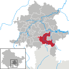
- Probstzella
-
Probstzella 
Coordinates 50°31′57″N 11°22′43″E / 50.5325°N 11.37861°ECoordinates: 50°31′57″N 11°22′43″E / 50.5325°N 11.37861°E Administration Country Germany State Thuringia District Saalfeld-Rudolstadt Municipal assoc. Probstzella-Lehesten-Marktgölitz Local subdivisions 20 Mayor Marko Wolfram (SPD) Basic statistics Area 74.26 km2 (28.67 sq mi) Elevation 340 m (1116 ft) Population 3,349 (31 December 2010)[1] - Density 45 /km2 (117 /sq mi) Other information Time zone CET/CEST (UTC+1/+2) Licence plate SLF Postal code 07330 Area code 036735 Website www.einheitsgemeinde-probstzella.de Probstzella is a municipality in the district Saalfeld-Rudolstadt, in Thuringia, Germany.
History
Between 1945 and 1990 Probstzella station served as East German inner German border crossing for rail transport. The crossing was open for trains travelling between the Soviet Zone of occupation in Germany (till 1949, thereafter the East German Democratic Republic, or West Berlin and the American zone of occupation (till 1949) and thereafter the West German Federal Republic of Germany. The traffic was subject to the Interzonal traffic regulations, that between West Germany and West Berlin followed the special regulations of the Transit Agreement (1972).
Allendorf • Altenbeuthen • Arnsgereuth • Bad Blankenburg • Bechstedt • Cursdorf • Deesbach • Döschnitz • Dröbischau • Drognitz • Gräfenthal • Hohenwarte • Kamsdorf • Katzhütte • Kaulsdorf • Königsee • Lehesten • Leutenberg • Lichte • Mellenbach-Glasbach • Meura • Meuselbach-Schwarzmühle • Oberhain • Oberweißbach • Piesau • Probstzella • Reichmannsdorf • Remda-Teichel • Rohrbach • Rottenbach • Rudolstadt • Saalfeld • Saalfelder Höhe • Schmiedefeld • Schwarzburg • Sitzendorf • Uhlstädt-Kirchhasel • Unterweißbach • Unterwellenborn • WittgendorfReferences
- ^ "Bevölkerung nach Gemeinden, erfüllenden Gemeinden und Verwaltungsgemeinschaften" (in German). Thüringer Landesamt für Statistik. 31 December 2010. http://www.statistik.thueringen.de/datenbank/TabAnzeige.asp?tabelle=gg000102%7C%7C.
Categories:- Municipalities in Thuringia
- Inner German border
- Thuringia geography stubs
Wikimedia Foundation. 2010.


