- Meura
-
Meura 

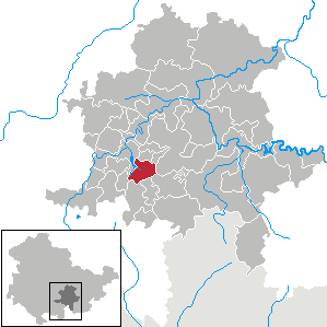
 MeuraLocation of Meura within Saalfeld-Rudolstadt district
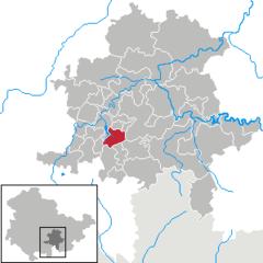
Coordinates 50°34′0″N 11°11′0″E / 50.566667°N 11.183333°ECoordinates: 50°34′0″N 11°11′0″E / 50.566667°N 11.183333°E Administration Country Germany State Thuringia District Saalfeld-Rudolstadt Municipal assoc. Mittleres Schwarzatal Mayor Ulrich Nordt Basic statistics Area 12.61 km2 (4.87 sq mi) Elevation 500-700 m Population 474 (31 December 2010)[1] - Density 38 /km2 (97 /sq mi) Other information Time zone CET/CEST (UTC+1/+2) Licence plate SLF Postal code 98744 Area code 036701 Website www.meura.de Meura is a municipality in the district Saalfeld-Rudolstadt, in Thuringia, Germany.
Allendorf • Altenbeuthen • Arnsgereuth • Bad Blankenburg • Bechstedt • Cursdorf • Deesbach • Döschnitz • Dröbischau • Drognitz • Gräfenthal • Hohenwarte • Kamsdorf • Katzhütte • Kaulsdorf • Königsee • Lehesten • Leutenberg • Lichte • Mellenbach-Glasbach • Meura • Meuselbach-Schwarzmühle • Oberhain • Oberweißbach • Piesau • Probstzella • Reichmannsdorf • Remda-Teichel • Rohrbach • Rottenbach • Rudolstadt • Saalfeld • Saalfelder Höhe • Schmiedefeld • Schwarzburg • Sitzendorf • Uhlstädt-Kirchhasel • Unterweißbach • Unterwellenborn • Wittgendorf
References
- ^ "Bevölkerung nach Gemeinden, erfüllenden Gemeinden und Verwaltungsgemeinschaften" (in German). Thüringer Landesamt für Statistik. 31 December 2010. http://www.statistik.thueringen.de/datenbank/TabAnzeige.asp?tabelle=gg000102%7C%7C.
Categories:- Municipalities in Thuringia
- Thuringia geography stubs

Wikimedia Foundation. 2010.