- Mosteiros (Ponta Delgada)
-
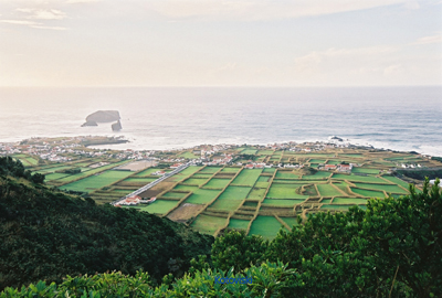
Mosteiros Civil Parish (Freguesia)  A coastal perspective of the village of Mosteiros, the westernmost settlement on the island of São Miguel
Official name: Freguesia dos Mosteiros Country  Portugal
Autonomous Region  Azores
Group Central Island São Miguel Municipality Ponta Delgada Localities Chã das Machadas, Lomba dos Homens, Lombinha, Mosteiros Center Lombinha - elevation 200 m (656 ft) - coordinates 37°53′1″N 25°48′58″W / 37.88361°N 25.81611°W Highest point Casa Velha - location Sete Cidades Massif, Mosteiros, Ponta Delgada - elevation 520 m (1,706 ft) - coordinates 37°52′44″N 25°47′31″W / 37.87889°N 25.79194°W Lowest point Sea Level - location Atlantic Ocean Length 4.42 km (3 mi), West-East Width 4.14 km (3 mi), North-South Area 9.20 km2 (4 sq mi) - land 8.6 km2 (3 sq mi) - urban .6 km2 (0 sq mi) Population 1,196 (2001) Density 130 / km2 (337 / sq mi) LAU Freguesia/Junta Freguesia - location Rua Pensões, Mosteiros, Ponta Delgada President Junta Paulo Jorge Franco Almeida Timezone Azores (UTC-1) - summer (DST) Azores (UTC0) ISO 3166-2 code PT- Postal Zone 9555-156 Mosteiros Area Code & Prefix (+351) 292 XXX-XXXX Demonym Micalense Patron Saint Nossa Senhora da Conceição Parish Address Rua Pensões, 1
9555-156 MosteirosWikimedia Commons: Mosteiros (Ponta Delgada) Statistics from INE (2001); geographic detail from Instituto Geográfico Português (2010) Mosteiros is a civil parish in the municipality of Ponta Delgada in the Azores. The population in 2001 was 1196, its density is 130/km² and the area is 9.2 km². It is located in the northwestern part of the island of São Miguel and is connected by roads to Ponta Delgada in the south and Ribeira Grande in the east. The mountains which are covered with lovely trees are to the east and a mountain range is situated in the southeast about 1 km away from the Atlantic Ocean.
Geography
The village is aligned from north to south with the major road link to Ponta Delgada and Ribeira Grande. The local agriculture is dominated by cattle farming, with some fruits and vegetables. Many of the hedges are made of bamboo. Another village with a cape lies to the southwest. Another cape is to the north which has a number of farms. The coastline of the parish is surrounded by rocks elevating up to 20 m.
There are two small islets to the northwest and three in the southwest including a large one further west and two smaller ones slightly east of the large islet. The word Mosteiros actually means "monastery" in the Portuguese language and the parish was named as such because the largest of these islets is shaped like a church.
Mosteiros has a school, a lyceum and a square (praça).
Categories:- Parishes of Ponta Delgada (Azores)
- Azores geography stubs
Wikimedia Foundation. 2010.