- Larose, Louisiana
Geobox Town
name = Larose
native_name =
other_name =
other_name1 =
category = CDP
image_size =
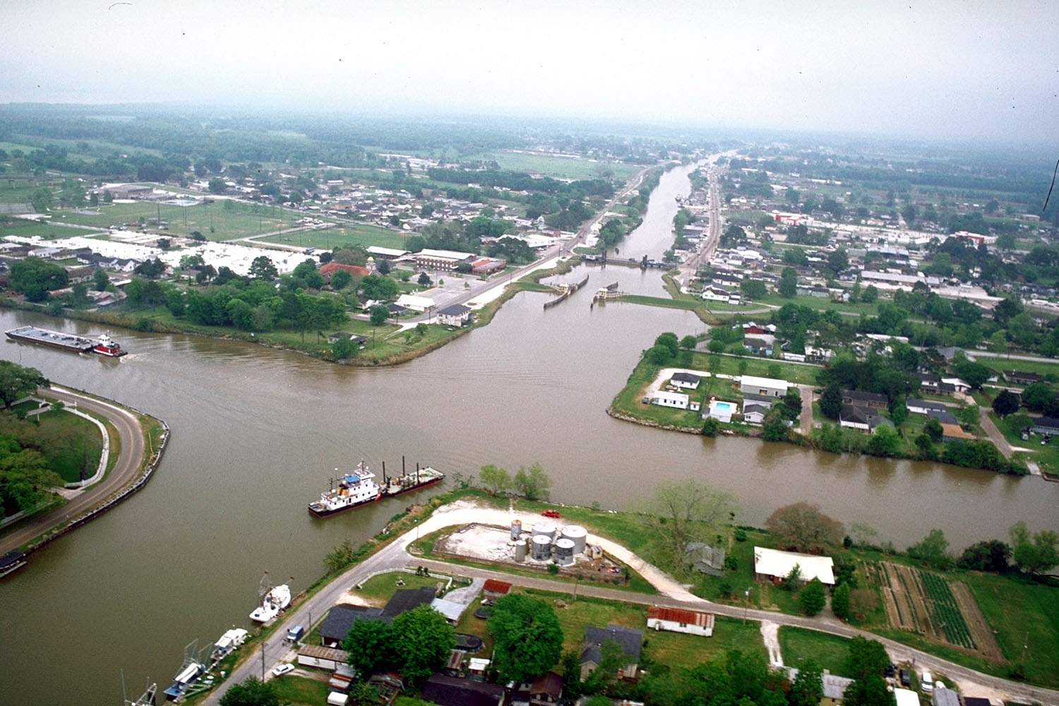
image_caption = Aerial view of Larose, Louisiana at the intersection of Bayou Lafourche and the Gulf Intracostal Waterway. View is to the east-southeast. The bayou runs off towards the Gulf at the top. The waterway crosses the picture left–right.
flag_size =
symbol =
symbol_size =
symbol_type =
nickname =
motto =
country = United States
state = Louisiana
region = Lafourche
region_type = Parish
area_imperial = 11.5
area_land_imperial = 11.2
area_water_imperial = 0.3
area_water_percentage = auto
area_percentage_round = 2
area_round = 1
location =
lat_d = 29
lat_m = 34
lat_s = 02
lat_NS = N
long_d = 90
long_m = 22
long_s = 34
long_EW = W
elevation_imperial = 7
elevation_round = 1
population_as_of = 2000
population = 7306
population_density_imperial = 651.9
population_density_round = 1
established_type =
established =
mayor =
timezone = CST
utc_offset = -6
timezone_DST = CDT
utc_offset_DST = -5
postal_code =
postal_code_type =
area_code = 985
area_code_type =
code2_type =
code2 =
free_type =
free =
free1_type =
free1 =

map_size =
map_caption = Location of Larose in Louisiana
map_locator = Louisiana
map1 = Map of USA LA.svg
map1_caption = Location of Louisiana in the United States
website =Larose is a
census-designated place (CDP) in Lafourche Parish,Louisiana ,United States . The population was 7,306 at the 2000 census. It is part of the Houma–Bayou Cane–Thibodaux Metropolitan Statistical Area.Geography
Larose is located at coor dms|29|34|2|N|90|22|34|W|city (29.567328, -90.376074)GR|1.
According to the
United States Census Bureau , the CDP has a total area of 11.5square mile s (29.9km² ), of which, 11.2 square miles (29.0 km²) of it is land and 0.3 square miles (0.9 km²) of it (2.95%) is water.Demographics
As of the
census GR|2 of 2000, there were 7,306 people, 2,479 households, and 1,990 families residing in the CDP. Thepopulation density was 651.9 people per square mile (251.6/km²). There were 2,643 housing units at an average density of 235.8/sq mi (91.0/km²). The racial makeup of the CDP was 85.57% White, 5.65% African American, 3.86% Native American, 2.38% Asian, 0.83% from other races, and 1.70% from two or more races. Hispanic or Latino of any race were 2.52% of the population.There were 2,479 households out of which 38.8% had children under the age of 18 living with them, 66.2% were married couples living together, 9.9% had a female householder with no husband present, and 19.7% were non-families. 16.2% of all households were made up of individuals and 7.3% had someone living alone who was 65 years of age or older. The average household size was 2.90 and the average family size was 3.24.
In the CDP the population was spread out with 27.2% under the age of 18, 8.9% from 18 to 24, 30.4% from 25 to 44, 21.0% from 45 to 64, and 12.5% who were 65 years of age or older. The median age was 35 years. For every 100 females there were 96.7 males. For every 100 females age 18 and over, there were 93.7 males.
The median income for a household in the CDP was $38,141, and the median income for a family was $45,126. Males had a median income of $32,020 versus $19,922 for females. The
per capita income for the CDP was $15,541. About 10.2% of families and 15.5% of the population were below thepoverty line , including 24.3% of those under age 18 and 13.6% of those age 65 or over.References
Wikimedia Foundation. 2010.