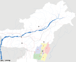
New Lamka

New Lamka
New Lamka
—  town  —
New Lamka
Location of New Lamka
in Manipur and India
Coordinates 24°19′45″N 93°41′33″E / 24.32917°N 93.6925°E / 24.32917; 93.6925Coordinates: 24°19′45″N 93°41′33″E / 24.32917°N 93.6925°E / 24.32917; 93.6925
Country India
State Manipur
District(s) Churachandpur
Nearest city Imphal
Parliamentary constituency Outer Manipur
Civic agency Village Authority
Time zone IST (UTC+05:30)

New Lamka is a residential colony of Lamka town in Churachandpur district, Manipur, India. It is located on the southern fringe of Lamka Town about a kilometer south of the civic centre.

History

The community started out as neighborhoods known as vengs, such as College Veng, Dorcas Veng, Elim Veng, Go Cin Khup Veng, Hebron Veng, Sim Veng , Zion Veng, Veng Nuam and Khomin thang, and today it is one of the most rapidly expanding parts of the city. New Lamka is divided by a number of streets and is dominated by the ethnic Paite community.

New Lamka

Most of the educational institutions of the District are located within New Lamka. There are various colleges and institutions including Rayburn College, Lamka College, Rayburn High School, St. Paul's Institute, Ebenezer Academy, St Peter's School, Dr BR Ambedkar's School and South Point School located in the vicinity of the town.

The Sports Complex is also situated at New Lamka, in Khominthang.


Wikimedia Foundation. 2010.

Игры ⚽ Поможем решить контрольную работу

Look at other dictionaries:

  • Churachandpur district — This article is about the district. For its eponymous headquarters, see Churachandpur. Churachandpur   district   …   Wikipedia

  • Mary Kom — Personal information Nationality  India Born 1 March 1983 (1983 03 01) (age 28) Kangathei, CCpur Subdiv, Manipur …   Wikipedia

  • Hiangtam — Historical Significance = Hiangtam is a small, but historic village on the Indo Myanmar border. It is one of the oldest settlement of the Zou community in Manipur, India. It is located within Churachandpur district of Manipur. Hiangtam is best… …   Wikipedia

  • Hiangzou — Infobox Indian Jurisdiction native name=Hiangzou | type = town| latd = 24.3|longd=93.15 locator position=left| state name=Manipur district = Churachandpur altitude=914.4 population as of=2001 population total=| Hiangzou is a new ward within… …   Wikipedia

  • Vangteh — is a large village in present Tedim township of Chin State, Myanmar (Burma). It is sometimes spelled as Wunkathe, probably a mispronunciation by Burmese guides when the British came to the land for the first time, [Bertram S. Carey and Henry N.… …   Wikipedia

  • List of sovereign states — List of nations and List of countries redirect here. For other country lists, see Lists of countries and territories. For other national lists, see Lists of nations. For non sovereign dependencies, see Dependent territory. This is a list of… …   Wikipedia

  • Chin State — Not to be confused with Chinland (Lairam), the Laimi inhabited areas of Bangladesh, India and Burma (Myanmar). Chin State ချင်းပြည်နယ်‌   State   …   Wikipedia

  • List of sovereign states and dependent territories in Asia — This is a list of sovereign states and dependent territories in Asia. It includes both fully recognized states, states with limited recognition, and dependent territories of both Asian and non Asian states. The divisions between Asia and Europe… …   Wikipedia

  • Zomi — is the name of an ethnic group of people that occupy Northwest Burma, Northeast India, and Northeast Bangladesh, and normally known as Lushai, Chin and Kuki to the outsiders. However, a single name Chin or Lushai or Kuki has technical limitation… …   Wikipedia

  • Sizang — The Sizang people are mainly the descendants of Pu Suantak and related clans, and their adopted sons and daughters. The Sizang valley is situated in the present day Chin State, Burma, founded by the descendants of the Pu Suantak, when they moved… …   Wikipedia

Share the article and excerpts

Direct link
Do a right-click on the link above
and select “Copy Link”