- Markagunt Plateau
-
Coordinates: 37°37′N 112°50′W / 37.617°N 112.833°W
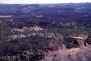 Blocky unvegetated lava flows known as the Black Rock Desert extend from near Miller Knoll to the SE. These flows, which also extend NE to near Panguitch Lake, are among the youngest features of the Markagunt Plateau volcanic field.
The Markagunt Plateau is an 800-square-mile (2,100 km2) plateau located in southwestern Utah between Interstate 15 and U.S. Route 89. It is one of the plateaus that make up the High Plateaus Section of the Colorado Plateau. The plateau encompasses Cedar Breaks National Monument and is part of Cedar Mountain District of Dixie National Forest. The name is derived from a Piute word meaning "Highland of Trees".
The Markagunt Plateau volcanic field is an area of basaltic cinder cones and blocky lava flows. The most recent flows are 1050 years old and were preceded by a series of trachytic, andesitic and rhyolitic lava. The field lies east of Cedar Breaks National Monument. Navajo Lake was formed when a lava flow dammed a creek on the plateau.[1] Mammoth Cave is a lava tube cave located on the plateau.[2]
See also
References
Categories:- Plateaus of Utah
- Colorado Plateau
- Landforms of Garfield County, Utah
- Landforms of Iron County, Utah
- Landforms of Kane County, Utah
- Landforms of Washington County, Utah
- Volcanoes of Utah
- Utah geography stubs

Wikimedia Foundation. 2010.