- Mynydd y Dref
-
Mynydd y Dref (Conwy Mountain) 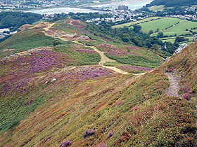
View down Conwy Mountain, with the town of Conwy in the distanceElevation 244 m (801 ft) Location Location Conwy,  Wales
WalesRange Snowdonia Coordinates 53°16′59″N 3°51′45″W / 53.2831°N 3.8624°WCoordinates: 53°16′59″N 3°51′45″W / 53.2831°N 3.8624°W OS grid SH759778 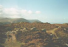 Castell Caer Seion - the Iron Age fort on Conwy Mountain.
Mynydd y Dref (Welsh : "Mountain of the Town") or Conwy Mountain is a hilly area to the west of the town of Conwy, in North Wales. To the north it overlooks the sea of Conwy Bay, and to the south lie the foothills of the Carneddau range of Mountains, of which it forms a part. Mynydd y Dref is the remains of an ancient volcano that erupted about 450 million years ago.[1]
At the summit of Conwy Mountain are the Neolithic Hut Circles and the Iron Age hillfort of Castell Caer Seion (sometimes called Castell Caer Lleion). Castell Caer Seion comprised a stone walled fort, and remains show this to have been an extensive site, incorporated more than 60 hut circles and levelled platform houses, and with a citadel and outposts.
Limited excavations were undertaken in 1951. No datable remains were found, only slingstones, querns and stone pestles and mortars, which suggests that, unlike many hillforts in north Wales, this site was not reoccupied in the late Roman period.[2]
Millstone was quarried on Conwy Mountain during the Napoleonic wars.
Tracks and footpaths cross Conwy Mountain, and many walkers, which can be accessed from Sychnant Pass at its western end. The route along Conwy Mountain comprises a section of the North Wales Path, a way-marked long distance walk of some 60 miles which runs close to the North Wales coast between Prestatyn in the east and Bangor in the west.
External links
References
Towns Other Settlements Betws-y-coed • Caerhun • Dolgarrog • Eglwysbach • Glan Conwy • Henryd • Llanbedr-y-cennin • Llanddoged • Llangelynnin • Llanrhychwyn • Maenan • Rowen • Tal-y-bont • Tal-y-Cafn • Trefriw • Tyn-y-groes •
Rivers & Streams Afon Conwy • Afon Crafnant • Afon Geirionydd • Afon Hiraethlyn • Afon Machno • Afon Lledr • Afon Llugwy • Afon Gallt y Gwg • Nant y Goron • Afon Ddu (1) • Afon Porth-llwyd • Afon Dulyn • Afon Ddu (2) • Afon Garreg-wen • Ffrwd Cerriguniawn • Afon Melynllyn • Afon Roe • Afon Tafolog • Afon Gyffin •
Lakes Llyn Crafnant • Llyn Elsi • Llyn Geirionydd • Llyn y Parc •
Waterfalls Grey Mare's Tail • Fairy Falls •
Hills & Mountains Mynydd y Dref • Tal y Fan • Bwlch-y-Ddeufaen • Cefn Cyfarwydd • Mynydd Hiraethog •
Castles & Forts Canovium • Conwy Castle • Gwydir Castle • Pen y Gaer •
Other Features Bodnant Garden • Conwy RSPB reserve • Gwydir Forest • Moel Maelogan • Snowdonia National Park •
Transport A470 • B5106 • Conwy Valley Line •
Railway Stations Categories:- Geography of Conwy
- Volcanoes of Wales
- Ordovician volcanoes


Wikimedia Foundation. 2010.