- Traer, Iowa
Infobox Settlement
official_name = Traer, Iowa
settlement_type =City
nickname =
motto =
imagesize =
image_caption =
image_
imagesize =
image_caption =
image_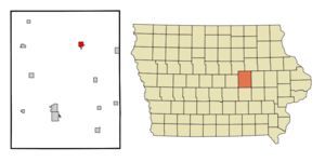
mapsize = 250px
map_caption = Location of Traer, Iowa
mapsize1 =
map_caption1 =subdivision_type = Country
subdivision_name =
subdivision_type1 = State
subdivision_name1 =
subdivision_type2 = County
subdivision_name2 = Tama
government_footnotes =
government_type =
leader_title =
leader_name =
leader_title1 =
leader_name1 =
established_title =
established_date =unit_pref = Imperial
area_footnotes =area_magnitude =
area_total_km2 = 2.9
area_land_km2 = 2.9
area_water_km2 = 0.0
area_total_sq_mi = 1.1
area_land_sq_mi = 1.1
area_water_sq_mi = 0.0population_as_of = 2000
population_footnotes =
population_total = 1594
population_density_km2 = 558.4
population_density_sq_mi = 1446.4timezone = Central (CST)
utc_offset = -6
timezone_DST = CDT
utc_offset_DST = -5
elevation_footnotes =
elevation_m = 279
elevation_ft = 915
latd = 42 |latm = 11 |lats = 29 |latNS = N
longd = 92 |longm = 27 |longs = 52 |longEW = Wpostal_code_type =
ZIP code
postal_code = 50675
area_code = 319
blank_name = FIPS code
blank_info = 19-78735
blank1_name = GNIS feature ID
blank1_info = 0462294
website =
footnotes =Traer is a city in Tama County,
Iowa ,United States . The population was 1,594 at the 2000 census. James "Tama Jim" Wilson lived in Traer after serving as U.S. Secretary of Agriculture and was buried in a cemetery northwest of the town in 1920. Traer is known for the iron winding staircase that originally lead to the office of the local newspaper. The staircase is freestanding, reverse-spiral and connected to the building with a suspended walkway, a somewhat rare arrangement.Municipal services
Services provided by the city include a fire department, an ambulance service,
North Tama County Community Schools , a swimming pool, a public library, an airport, and two parks.Government
The city is governed by a
mayor-council government , with a five-member council. It employs an attorney, a treasurer, a clerk and deputy clerk, and a gas and building inspector. The city runs multiple committees, on finance, streets, airport and garbage, recreation, public services, and protection. City boards include those responsible for the library, the airport, the parks, the memorial building, planning and zoning, the Wilson Nature Preserve, and historic preservation.Geography
Traer is located at coor dms|42|11|29|N|92|27|52|W|city (42.191495, -92.464374)GR|1, in Perry Township.
According to the
United States Census Bureau , the city has a total area of 1.1square mile s (2.8km² ), all of it land.The
zip code for Traer is 50675; it is inarea code 319 ; and it lies in theCentral Standard Time Zone .Important roads in Traer include
U.S. Route 63 andIowa Highway 8 .Demographics
As of the
census GR|2 of 2000, there were 1,594 people, 686 households, and 443 families residing in the city. Thepopulation density was 1,446.4 people per square mile (559.5/km²). There were 728 housing units at an average density of 660.6/sq mi (255.5/km²). The racial makeup of the city was 99.31% White, 0.31% African American, 0.13% Asian, and 0.25% from two or more races. Hispanic or Latino of any race were 0.13% of the population.There were 686 households out of which 25.2% had children under the age of 18 living with them, 55.5% were married couples living together, 6.0% had a female householder with no husband present, and 35.3% were non-families. 31.0% of all households were made up of individuals and 20.1% had someone living alone who was 65 years of age or older. The average household size was 2.21 and the average family size was 2.75.
In the city the population was spread out with 20.9% under the age of 18, 6.1% from 18 to 24, 23.1% from 25 to 44, 21.7% from 45 to 64, and 28.2% who were 65 years of age or older. The median age was 45 years. For every 100 females there were 86.4 males. For every 100 females age 18 and over, there were 81.4 males.
The median income for a household in the city was $35,329, and the median income for a family was $43,375. Males had a median income of $30,882 versus $20,670 for females. The
per capita income for the city was $17,811. About 4.9% of families and 7.0% of the population were below thepoverty line , including 7.6% of those under age 18 and 8.0% of those age 65 or over.References
External links
* [http://www.traer.com/visit/winding_stairs.html Traer's winding stairs]
* [http://www.traer.com/fire Traer Fire Department]
* [http://traer.com.tripod.com/wilson/index.html Wilson Nature Preserve]
Wikimedia Foundation. 2010.