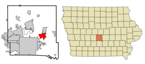
- Altoona, Iowa
Infobox Settlement
official_name = Altoona, Iowa
settlement_type =City
nickname =
motto =
imagesize =
image_caption =
image_
imagesize =
image_caption =
image_
mapsize = 250px
map_caption = Location of Altoona, Iowa
mapsize1 =
map_caption1 =subdivision_type = Country
subdivision_name =
subdivision_type1 = State
subdivision_name1 =
subdivision_type2 = County
subdivision_name2 = Polk
government_footnotes =
government_type =
leader_title =
leader_name =
leader_title1 =
leader_name1 =
established_title =
established_date =unit_pref = Imperial
area_footnotes =
area_magnitude =
area_total_km2 = 18.4
area_land_km2 = 18.4
area_water_km2 = 0.0
area_total_sq_mi = 7.1
area_land_sq_mi = 7.1
area_water_sq_mi = 0.0population_as_of = 2000
population_footnotes =
population_total = 10345
population_density_km2 = 562.2
population_density_sq_mi = 1456.2timezone = Central (CST)
utc_offset = -6
timezone_DST = CDT
utc_offset_DST = -5
elevation_footnotes =
elevation_m = 291
elevation_ft = 955
latd = 41 |latm = 39 |lats = 0 |latNS = N
longd = 93 |longm = 28 |longs = 21 |longEW = Wpostal_code_type =
ZIP code
postal_code = 50009
area_code = 515
blank_name = FIPS code
blank_info = 19-01630
blank1_name = GNIS feature ID
blank1_info = 0454160
website =
footnotes =Altoona is a city in Polk County,
Iowa ,United States and a part of the Des Moines–West Des Moines Metropolitan Statistical Area. The population was 10,345 at the 2000 census; a special census taken in August 2005 counted 13,301 residents. [cite web|author=City of Altoona|title=Council Minutes, December 19, 2005|url=http://www.altoona-iowa.com/filecab/2005-12-19%20Council%20Minutes.pdf|format=PDF|year=2005|accessdate=2006-05-17]Altoona is home of Adventureland, an
amusement park , andPrairie Meadows , ahorse racing track andcasino .History
Altoona incorporated as a city on March 11, 1876. It is named for the
Latin word for "high," "altus", after surveyor Julian B. Bausman discovered that Altoona was the highest point on the Des Moines Valley Railroad between Des Moines and Keokuk. [cite book|last=Henning|first=Barbara Beving Long|coauthors=Patrice K. Beam|year=2003|title=Des Moines and Polk County: Flag on the Prairie|publisher=American Historical Press|location=Sun Valley, California|id=ISBN 1-892724-34-0]Geography
Altoona is located at coor dms|41|39|0|N|93|28|21|W|city (41.650089, -93.472546)GR|1.
According to the
United States Census Bureau , the city has a total area of 7.1square mile s (18.4km² ), all of it land.Demographics
As of the
census GR|2 of 2000, there were 10,345 people, 3,850 households, and 2,895 families residing in the city. Thepopulation density was 1,835.4 people per square mile (708.2/km²). There were 3,959 housing units at an average density of 557.3/sq mi (215.3/km²). The racial makeup of the city was 97.11% White, 0.92% African American, 0.33% Native American, 0.46% Asian, 0.41% Pacific Islander, 0.77% from other races, and 1.20% from two or more races. Hispanic or Latino of any race were 1.65% of the population.There were 3,850 households out of which 43.7% had children under the age of 18 living with them, 58.5% were married couples living together, 14.0% had a female householder with no husband present, and 24.8% were non-families. 19.9% of all households were made up of individuals and 5.4% had someone living alone who was 65 years of age or older. The average household size was 2.66 and the average family size was 3.08.
In the city the population was spread out with 30.6% under the age of 18, 8.1% from 18 to 24, 33.3% from 25 to 44, 20.3% from 45 to 64, and 7.7% who were 65 years of age or older. The median age was 32 years. For every 100 females there were 91.4 males. For every 100 females age 18 and over, there were 85.9 males.
The median income for a household in the city was $50,162, and the median income for a family was $58,306. Males had a median income of $36,030 versus $28,205 for females. The
per capita income for the city was $20,336. About 4.0% of families and 5.5% of the population were below thepoverty line , including 7.2% of those under age 18 and 4.2% of those age 65 or over.Education
Altoona (along with nearby Runnells, Mitchellville, and parts of Pleasant Hill and Des Moines) is a part of the
Southeast Polk Community School District , and its students attend Southeast Polk High School. The town is home to four of the eight elementary schools in the district: Altoona, Centennial, Clay, and Willowbrook. The current Altoona Elementary building also served as the town's high school until it joined the Southeast Polk consolidation in 1962.Famous residents
*
Kyle Orton ,Chicago Bears quarterback
* Neal Smith, formerUnited States Congress man
*Jamie Solinger , 1992Miss Teen USA References
External links
* [http://www.altoona-iowa.com/ Official City Website]
* [http://www.altoonachamber.org/ Altoona Chamber of Commerce]
* [http://www.se-polk.k12.ia.us/ Southeast Polk Community School District]
Wikimedia Foundation. 2010.


