- Old Rag Mountain
-
Old Rag Mountain 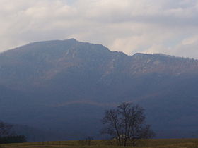
Old Rag MountainElevation 3,284 ft (1,001 m) [1] Prominence 1,355 ft (413 m) [2] Location Location Madison County, Virginia, USA Range Blue Ridge Mountains Coordinates 38°33′06.6″N 78°18′52.3″W / 38.551833°N 78.314528°WCoordinates: 38°33′06.6″N 78°18′52.3″W / 38.551833°N 78.314528°W[1] Topo map USGS Old Rag Mountain Geology Type Granite Age of rock Precambrian Climbing Easiest route Hike Old Rag Mountain is a popular hiking destination with a summit elevation of 3,291 feet (1,003 m), located in the Blue Ridge Mountains of the Shenandoah National Park in Virginia's Madison County, near Sperryville.
In contrast to most mountains of the Blue Ridge, Old Rag has an exposed (rocky) summit.
Contents
Geology
Old Rag Mountain is underlain by Old Rag Granite, named for its ubiquitous exposure on the mountain, formed during the Grenville Orogeny about a billion years ago. About 400 million years after the Grenville orogeny during the Catoctin Formation, deposition of basaltic magma occurred during the formation of the Iapetus Ocean forming a layer of greenstone over the granite. This was followed by the Weverton Formation, Harpers Formation, and Antietam formation in which sand and rock sedimented on the ocean floor forming quartzite and sandstone deposits. Finally a period of sedimentation of shells and skeletons of foraminifera resulted in deposition of a layer of limestone. Approximately 700 million years after the Greenville Orogeny, the Iapetus Ocean began to close resulting in the Alleghenian Orogeny when the Old Rag Granite and layers of rock deposited upon it where transported westward and eventually thrust up over the limestone bed around it, forming Old Rag and the Blue Ridge Mountains.[3]
Recreation
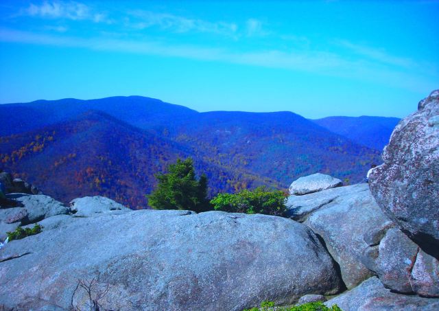
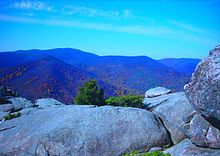 View from the summit of Old Rag mountain.
Hiking
The summit of Old Rag is accessible via a system of trails in Shenandoah National Park. The shorter, most common way is from a parking area at the end of County Route 601 off Route 231, at the base of the mountain. A 7.1 miles (11.4 km) circuit hike or a 5.4 miles (8.7 km) out-and-back hike to the summit can be made. The circuit hike makes use of the Ridge Trail which ascends the mountain 1.6 miles (2.6 km) to the first false summit. The trail then turns into a rock scramble, which can be strenuous for inexperienced hikers, for 1.1 miles (1.8 km) to the summit and intersection with the Saddle Trail which descends 1.9 miles (3.1 km) down the saddle of the ridge past Byrds Nest #1 shelter and Old Rag shelter to the junction with Weakley Hollow Fire Road. The Fire Road then descends 2.5 miles (4.0 km) to the Old Rag parking area . This pleasantly convenient parking area was closed in 2010. All parking is now limited to the lower field parking area adding a half mile walk on asphalt. Likewise the summit can be reached from Skyline Drive by following Old Rag Fire Road from the drive at milepost 43 to its eastern terminus with the Saddle Trail and then follow that trail to the summit.[4]
Nearby hiking on the Blue Ridge Parkway also includes such destinations as Humpback Rock, and Bald Mountain.
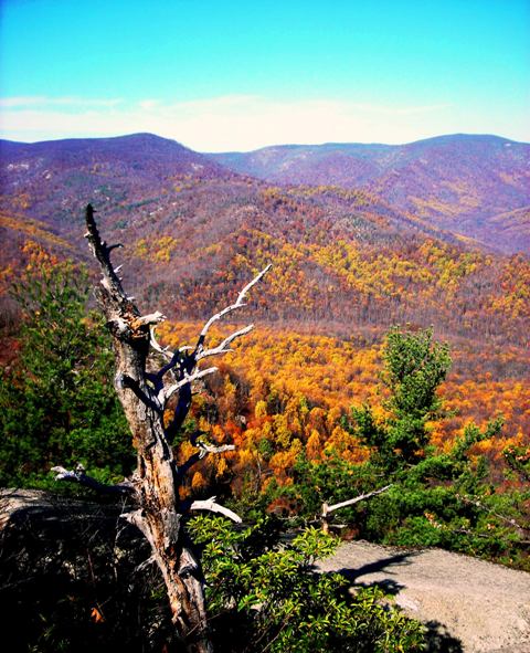
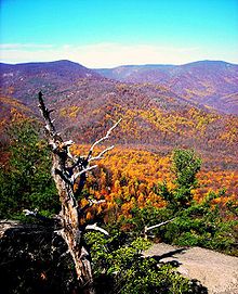 View from the summit of Old Rag mountain.
Rock Climbing
Old Rag is a unique destination for rock climbing in the mid-Atlantic region. Its large granite exposures offer rock climbers an experience similar to that provided by the granite rocks of the Sierra Nevada Mountains, Yosemite, North Carolina, and New Hampshire. It boasts splitter cracks, dihedrals, and crystal pinching slabs.
The climbs are between 50 and 100 feet (15 and 30 m) in length, and range in difficulty from beginner to expert (5.4- to 5.12+ on the Yosemite Decimal System).
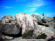 Rock scramble near the summit of Old Rag mountain.
References
- ^ a b "Old Rag Mtn". NGS data sheet. U.S. National Geodetic Survey. http://www.ngs.noaa.gov/cgi-bin/ds_mark.prl?PidBox=AH8733. Retrieved 2008-11-29.
- ^ "Old Rag Mountain, Virginia". Peakbagger.com. http://www.peakbagger.com/peak.aspx?pid=7662. Retrieved 2008-11-29.
- ^ Hackley, Paul. "A Hiker's Guide to the Geology of Old Rag Mountain, Shenandoah National Park, Virginia". United States Geological Survey. http://pubs.usgs.gov/of/2000/of00-263/of00-263.pdf. Retrieved 2008-11-29.
- ^ Lee Sheaffer, ed (1999). Appalachian Trail Guide to Shenandoah National Park (12th ed ed.). Potomac Appalachian Trail Club. ISBN 0-915746-84-0.
External links
- "Shenandoah National Park". National Park Service. http://www.nps.gov/shen. Retrieved 2008-11-29.
- "Old Rag Mountain, VA". LocalHikes.com. http://www.localhikes.com/Hikes/Old_Rag_Mt_0000.asp. Retrieved 2008-11-29.
- "Old Rag Mountain - SNP, Virginia". Shenandoah National Park. HikingUpward.com. http://www.hikingupward.com/SNP/OldRag/. Retrieved 2008-11-29.
- "Climber's Guide to Old Rag Mountain - SNP, Virginia". old-rag-guide.blogspot.com. http://old-rag-guide.blogspot.com/. Retrieved 2011-04-23.
Categories:- Mountains of Virginia
- Blue Ridge Mountains
- Geography of Madison County, Virginia
- Shenandoah National Park
- Visitor attractions in Madison County, Virginia


Wikimedia Foundation. 2010.