- Municipal Borough of Stretford
-
For the town, see Stretford.
Stretford Motto: Service and Efficiency Geography Status Local Government District 1868–1894
Urban district 1894–1933
Municipal borough 1933–19741911 area 3,240 acres (13.1 km2) 1961 area 3,532 acres (14.29 km2) HQ Stretford Town Hall History Created 1868 Abolished 1974 Succeeded by Metropolitan Borough of Trafford Demography 1901 population 30,436 1931 population 56,791 1971 population 54,316 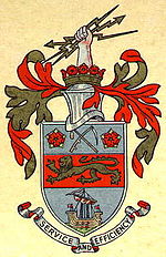
Stretford was, from 1868 to 1974, a local government district coterminate with the town of Stretford in the then county of Lancashire, England.[1]
Contents
Local Board and Urban District
In 1868 the township of Stretford adopted the Local Government Act 1858, and a local board was formed to govern the town.[2] In 1889 the district became part of the administrative county of Lancashire.
The Local Government Act 1894 reconstituted the local board's area as Stretford Urban District. An urban district council of eighteen members replaced the local board. The urban district was divided into six wards, each returning three councillors: Clifford, Cornbrook, Longford, Stretford, Talbot and Trafford.[3]
In 1933 the urban district was enlarged when the Davyhulme area was added on the abolition of the neighbouring Barton upon Irwell Rural District by a county review order.[1]
Municipal borough
In 1933 the urban district was granted a charter of incorporation and Stretford became a municipal borough. The charter was formally presented by the Earl of Derby, Lord Lieutenant of Lancashire at a Charter Day celebration held on 16 September.[4] At the same time the Earl officially opened the Town Hall.[5]
Political control
The borough council consisted of a mayor, eight aldermen and twenty-four councillors. The charter mayor was Sir Thomas Robinson, who had been Member of Parliament for the Stretford constituency until 1931.[4] One third of the councillors were elected annually, while half of the aldermen were chosen by the council every three years. The Conservative Party controlled the borough from 1933 to 1945. From 1945 to 1947 the council was under no overall control.[6] The Conservatives regained control in 1947 and held it until 1962.[7] After two years with no party in a majority, the Labour and Conservative parties alternated in power for the last ten years of the borough's existence: Labour had a majority from 1964 to 1967, Conservatives 1967 to 1972 and Labour from 1972 to 1974.[8]
Coat of arms
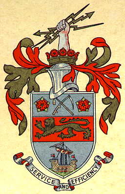
On February 20, 1933, Stretford Urban District Council was granted armorial bearings by the College of Arms.[9] The arms continued in use when the borough was incorporated. The arms were blazoned as follows:
Argent, on a fesse gules between in chief a flail and a scythe in saltire proper between two roses of the second, barbed and seeded, and in base upon waves of the sea a lymphad, sails furled, oars in action, proper a lion passant Or; and for a Crest: Issuant from a coronet composed of eight roses as in the Arms set upon a rim Or, a cubit arm, the hand proper grasping a thunderboltgold. Mantled gules doubled Or.[9]The lion in the centre of the shield represented John of Gaunt, while the red roses were the county emblems for Lancashire. The "lymphad" or ancient ship at the base of the arms indicated that the area had maritime connections via the Rivers Mersey and Irwell. The arms were completed by a crossed flail and scythe. The scythe was emblematic of the agricultural past of the area, while the flail came from the arms of the Trafford family.
The crest upon the helm above the shield was an arm grasping a golden thunderbolt, symbolising the modern industries of Stretford. The design was completed by a coronet of Lancastrian roses.[10]
Abolition
The borough was abolished by the Local Government Act 1972, and its former area transferred to the new county of Greater Manchester in 1974, to form part of the Metropolitan Borough of Trafford.
References
- ^ a b "A vision of Stretford MB/UD". A Vision of Britain Through Time. http://www.visionofbritain.org.uk/unit_page.jsp?u_id=10186687. Retrieved 2007-08-31.
- ^ London Gazette: no. 23368. p. 2107. 7 April 1868. Retrieved on 17 August 2008.
- ^ William Farrer & J. Brownbill (editors) (1911). "Townships: Stretford". A History of the County of Lancaster: Volume 4. British History Online. http://www.british-history.ac.uk/report.aspx?compid=41436. Retrieved 2008-08-17.
- ^ a b Stretford Town Hall: Opening By Lord Derby, The Times, September 18, 1933, p. 9
- ^ "Stretford Charter Day". Trafford Council. http://www.trafford.gov.uk/content/tca/display_image.asp?ImageID=5280. Retrieved 2007-07-15.
- ^ The Times, November 2, 1946, p.8
- ^ The Times, November 3, 1947, p.6; May 11, 1962, p.10
- ^ The Times, May 8, 1964, p.10; May 12, 1967, p.3; May 6, 1972
- ^ a b Geoffrey Briggs, Civic and corporate Heraldry: A Dictionary of Impersonal Arms of England, Wales & N. Ireland, London, 1971
- ^ C. Wilfrid Scott-Giles, Civic Heraldry of England and Wales, 2nd edition, London, 1953
Categories:- Districts of England created by the Local Government Act 1894
- Districts of England abolished by the Local Government Act 1972
- History of Lancashire
- History of Greater Manchester
- Local government in Trafford
- Municipal boroughs of England
Wikimedia Foundation. 2010.