- Ottendorf-Okrilla
-
Ottendorf-Okrilla 

 Ottendorf-OkrillaLocation of Ottendorf-Okrilla within Bautzen district
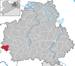

Coordinates 51°10′45″N 13°49′34″E / 51.17917°N 13.82611°ECoordinates: 51°10′45″N 13°49′34″E / 51.17917°N 13.82611°E Administration Country Germany State Saxony Admin. region Dresden District Bautzen Local subdivisions 3 Mayor Michael Langwald (Ind.) Basic statistics Area 25.88 km2 (9.99 sq mi) Elevation 180 m (591 ft) Population 9,866 (31 December 2010)[1] - Density 381 /km2 (987 /sq mi) Other information Time zone CET/CEST (UTC+1/+2) Licence plate BZ Postal code 01458 Area code 035205 Website www.ottendorf-okrilla.de Ottendorf-Okrilla is a municipality in the Bautzen district, Free State of Saxony, Germany. It is located 20 km northeast of Dresden.
Contents
Coat of arms
The coat of arms includes a heart with three arrows with two flowers on each side and a stem of a flower on a bottom. The color of the shield ranges from French to golf green.
Area
The area is 25.88 km². The length from north to south is 6 km and the east to west length is 7 km. The municipality has 26.20 km² of which 1.58 km² are commercially used.
Transportation
Ottendorf-Okrilla has its own access to the motorway A4 and is situated on the railroad track between Dresden and Königsbrück.
Boundaries
- district Weixdorf of Dresden
- district Großdittmannsdorf of Radeburg in the district Meißen
- municipalities of Laußnitz and Wachau in the Kamenz district
Districts ('Ortsteile')
History
Ottendorf-Okrilla was first mentioned in 1378.
Population
(December 31)
- 1998 - 10,253
- 1999 - 10,363
- 2000 - 10,343
- 2001 - 10,255
- 2002 - 10,273
- 2003 - 10,184
Economics and Infrastructure
Ottendorf-Okrilla has about 6,500 jobs of which 700 are in the industrial sector.
It is also the location of the letter processing center for the Dresden area of the Deutsche Post.
References
- ^ "Bevölkerung des Freistaates Sachsen jeweils am Monatsende ausgewählter Berichtsmonate nach Gemeinden" (in German). Statistisches Landesamt des Freistaates Sachsen. 31 December 2010. http://www.statistik.sachsen.de/download/010_GB-Bev/Bev_Gemeinde.pdf.
External links
Categories:- Municipalities in Saxony


Wikimedia Foundation. 2010.