- Demitz-Thumitz
-
Demitz-Thumitz Elementary school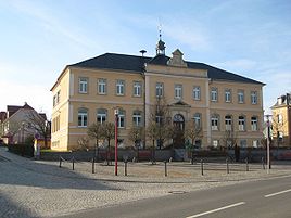


 Demitz-ThumitzLocation of Demitz-Thumitz within Bautzen district
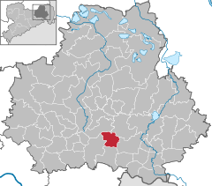

Coordinates 51°8′N 14°15′E / 51.13333°N 14.25°ECoordinates: 51°8′N 14°15′E / 51.13333°N 14.25°E Administration Country Germany State Saxony Admin. region Dresden District Bautzen Local subdivisions 9 Mayor Horst Wittholz Basic statistics Area 21.07 km2 (8.14 sq mi) Elevation 250 m (820 ft) Population 2,878 (31 December 2010)[1] - Density 137 /km2 (354 /sq mi) Other information Time zone CET/CEST (UTC+1/+2) Licence plate BZ Postal code 01877 Area code 03594 Website www.demitz-thumitz.de Demitz-Thumitz (Sorbian: Zemicy-Tumicy) is a municipality in the east of Saxony, Germany. It belongs to the district of Bautzen.
Contents
Geography
The municipality is situated at the edge of the Lausitzer Bergland (Lusatian Hills).
Villages
Several villages belong to the municipality:
- Demitz-Thumitz (Zemicy-Tumicy)
- Wölkau (Wjelkowy)
- Medewitz (Mjedźojz)
- Birkenrode (Brězyšćo)
- Rothnaußlitz (Čerwjene Noslicy)
- Cannewitz (Chanecy)
- Karlsdorf
- Pottschapplitz (Počaplicy)
- Pohla-Stacha (Palow-Stachow)
Transport
Demitz-Thumitz is located at the railroad line Dresden-Görlitz and the Bundesstraße 6 (Dresden-Bautzen).
References
- ^ "Bevölkerung des Freistaates Sachsen jeweils am Monatsende ausgewählter Berichtsmonate nach Gemeinden" (in German). Statistisches Landesamt des Freistaates Sachsen. 31 December 2010. http://www.statistik.sachsen.de/download/010_GB-Bev/Bev_Gemeinde.pdf.
Categories:- Municipalities in Saxony
- Saxony geography stubs


Wikimedia Foundation. 2010.