- Kake Airport
-
Kake Airport 
IATA: none – ICAO: PAFE – FAA LID: AFE Summary Airport type Public Owner State of Alaska DOT&PF - Southeast Region Serves Kake, Alaska Elevation AMSL 172 ft / 52 m Coordinates 56°57′41″N 133°54′37″W / 56.96139°N 133.91028°WCoordinates: 56°57′41″N 133°54′37″W / 56.96139°N 133.91028°W Map Location of airport in Alaska
 AFE
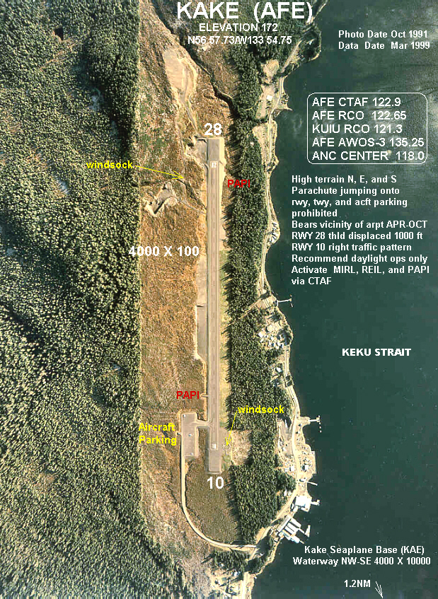
AFERunways Direction Length Surface ft m 11/29 4,000 1,219 Asphalt Statistics (2006) Aircraft operations 4,600 Source: Federal Aviation Administration[1] Kake Airport (ICAO: PAFE, FAA LID: AFE) is a state-owned public-use airport located one nautical mile (2 km) southeast of the central business district of Kake,[1] a city in the Petersburg Census Area of the U.S. state of Alaska. This airport is included in the National Plan of Integrated Airport Systems for 2011–2015, which categorized it as a general aviation airport.[2]
Scheduled airline service is available at Kake Seaplane Base (IATA: KAE, FAA LID: KAE).[3]
Contents
Facilities and aircraft
Kake Airport has one runway designated 11/29 with an asphalt surface measuring 4,000 by 100 feet (1,219 x 30 m).[1] For the 12-month period ending December 31, 2006, the airport had 4,600 aircraft operations, an average of 12 per day.[1]
See also
References
- ^ a b c d FAA Airport Master Record for AFE (Form 5010 PDF). Federal Aviation Administration. Effective 25 August 2011.
- ^ "2011–2015 NPIAS Report, Appendix A (PDF, 2.03 MB)". National Plan of Integrated Airport Systems. Federal Aviation Administration. 4 October 2010. http://www.faa.gov/airports/planning_capacity/npias/reports/media/2011/npias_2011_appA.pdf.
- ^ FAA Airport Master Record for KAE (Form 5010 PDF). Federal Aviation Administration. Effective 25 August 2011.
External links
- FAA Alaska airport diagram for Kake Airport (AFE) (GIF)
- FAA Alaska airport diagram for Kake Seaplane Base (KAE) (GIF)
- Resources for this airport:
- AirNav airport information for PAFE
- FlightAware airport information and live flight tracker for PAFE
- NOAA/NWS latest weather observations for PAFE
- SkyVector aeronautical chart for AFE
Categories:- Airports in the Petersburg Census Area, Alaska

Wikimedia Foundation. 2010.