- Old Union Crossing Covered Bridge
-
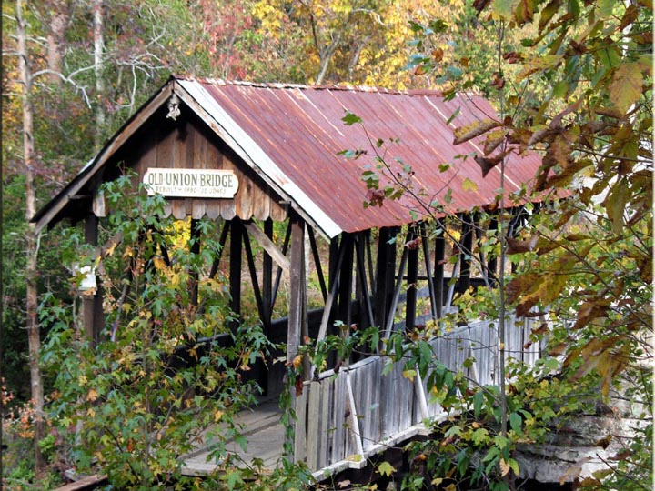
Old Union Crossing CB 
The Old Union Crossing Covered Bridge near Mentone, Alabama.Carries single lane motor traffic Crosses West Fork of the Little River Locale Mentone, Alabama Maintained by PRIVATE USE ID number 01-25-A (WGCB) Design Stringer truss Total length 90 ft (27 m) Construction end circa 1863 (rebuilt 1980) Coordinates 34°32′3.51″N 85°35′56.47″W / 34.5343083°N 85.5990194°WCoordinates: 34°32′3.51″N 85°35′56.47″W / 34.5343083°N 85.5990194°W The Old Union Crossing Covered Bridge is a privately owned wood & metal combination style covered bridge that spans the West Fork of the Little River in DeKalb County, Alabama, United States. It is located on an access road between Shady Grove Dude Ranch and Cloudmont Ski & Golf Resort on Lookout Mountain, which is off County Road 614 near the town of Mentone. Coordinates are 34°32′3.51″N 85°35′56.47″W / 34.5343083°N 85.5990194°W (34.534308, -85.599019).
Originally built circa 1863, the 90-foot (27 m) bridge is a Stringer truss construction over three spans. Its current WGCB number is 01-25-A, formerly 01-25-02. The Old Union Crossing Covered Bridge is one of five existing covered bridges in Alabama built before 1950 not listed on the National Register of Historic Places. It was rebuilt in 1980 over an existing cable bridge from the late 19th century.
This bridge has also been called the Tallasseehatchee Covered Bridge, but these are actually two different structures. A couple of sources contradict time and place of bridge movement if both names applied to the same bridge. According to the current owners as well as most sources, the Old Union Crossing Covered Bridge was moved from Lincoln, Alabama in 1972 to its current location near Mentone. In reference to a document released by the Alabama Historical Commission in the early 1980s which lists all historic covered bridges in the state as well as a September 4, 1975 news article from The Anniston Star, the Tallasseehatchee Covered Bridge (also spelled 'Tallahatchee') was moved from Wellington, Alabama to Piedmont, Alabama (both in Calhoun County) in early September 1975 for becoming part of a reconstructed pioneer village and Appalachian crafts center.[1] Unfortunately, this project eventually ceased. No information about the Tallasseehatchee Covered Bridge after the move nor of its continued existence is mentioned. It is most likely that this bridge is no longer extant.
Contents
History
According to the current owners, the Old Union Crossing Covered Bridge dates back to the American Civil War...possibly between 1863 and 1864. It was built by Union Army troops over Otter Creek (not Ottery Creek in nearby Calhoun County), now a drybed located near the town of Lincoln in either Talladega County or Calhoun County. The bridge was used as an access route by Union forces throughout the war. It is unknown whether or not the bridge was open to motor traffic in later years. The Old Union Crossing Covered Bridge was purchased in 1972 by Jack Jones, original owner of Cloudmont Ski & Golf Resort, and moved north to Lookout Mountain near Mentone. The covered section was built over an existing steel cable bridge in 1980, replacing an earlier bridge built over the Little River fork in 1969. Initially, the covered section had slanted stringers only. It was later changed to vertical stringers with low-end exterior sides. Sources say the covered bridge was initially 42 feet (13 m) in length. In comparison, the Tallasseehatchee Covered Bridge was 60 feet (18 m)...a Multiple King-post truss construction built in 1908. Either way, only the center portion of the current bridge is covered and not the entire 90-foot span.
In September 2004, the Old Union Crossing Covered Bridge sustained damage from Hurricane Ivan, primarily to the deck. The bridge was closed and remained under repairs as of late 2006, but is now fixed and once again open. Today, the bridge mostly serves as a crossing for horseback riders riding the trails to and from Shady Grove Dude Ranch. It also attracts history buffs and other visitors as well.
See also
References
- ^ "Alabama's Covered Bridges". AHC Document. Alabama Historical Commission. 2007-08-27. http://www.dorje.com/mailing-lists/seriders/articles/covered-bridges.txt.
- Dale J. Travis Covered Bridges. Old Union Crossing CB: Credits. Retrieved Aug. 27, 2007.
- Alabama Bureau of Tourism & Travel. Old Union Crossing CB: Credits. Retrieved Aug. 27, 2007.
- The Decatur Daily. Old Union Crossing CB: Credits. Retrieved Aug. 27, 2007.
- Cloudmont Ski & Golf Resort and Shady Grove Dude Ranch. Old Union Crossing CB: Credits. Retrieved Aug. 27, 2007.
- Blue Ridge Country. Old Union Crossing CB: Credits. Retrieved Aug. 27, 2007.
- Alabama Historical Commission (1969). Alabama's Covered Bridges. Retrieved Oct. 26, 2007.
- Alabama Department of Archives and History. Old Union Crossing CB: Credits. Retrieved Oct. 26, 2007.
- The Anniston Star (September 4, 1975), page 1A. Retrieved Oct. 26, 2007.
- The Anniston Star (June 11, 1972), page 9C. Retrieved Oct. 26, 2007.
External links
Categories:- Covered bridges in Alabama
- Bridges completed in 1863
- Buildings and structures in DeKalb County, Alabama
- Wooden bridges in the United States
- Transportation in DeKalb County, Alabama
- Visitor attractions in DeKalb County, Alabama
- Road bridges in Alabama
Wikimedia Foundation. 2010.