- Kelud
-
Kelud 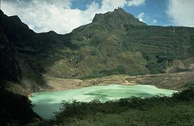
Elevation 1,731 m (5,679 ft) Listing List of volcanoes in Indonesia Location Location East Java, Indonesia Coordinates 7°55′48″S 112°18′29″E / 7.93°S 112.308°ECoordinates: 7°55′48″S 112°18′29″E / 7.93°S 112.308°E Geology Type Stratovolcano Volcanic arc/belt Pacific Ring of Fire Last eruption 2008 Kelud (Klut, Cloot, Kloet, Kloete, Keloed or Kelut) is a volcano located in East Java on Java in Indonesia. Like many Indonesian volcanoes and others on the Pacific Ring of Fire, Kelud is known for large explosive eruptions throughout its history. More than 30 eruptions have occurred since 1000 AD.[1]
Contents
1919 mudflow
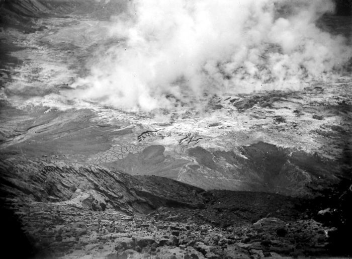
 The crater in 1919
On May 19, 1919, an eruption at Kelud killed an estimated 5,000 people, mostly through hot mudflows (also known as "lahars"). More recent eruptions in 1951, 1966, and 1990 have altogether killed another 250 people.[2] Following the 1966 eruption, the Ampera Tunnels were built (top and bottom) on the southwestern side of the crater to reduce (not drain out to empty) the water of crater lake and thus reduce the lahar hazard.
1990 eruption
A strong and explosive eruption on early February 1990 produced a 7 kilometres (4 mi) high column of tephra, heavy tephra falls and several pyroclastic flows. More than thirty people were killed. Workers continued to quarry the Ampera Tunnel despite the still-hot (90–400 °C / 194–752 °F) pyroclastic flow deposits which reached as high as 25 m (82 ft) and buried the tunnel's mouth.
2007 eruption
On October 16, 2007, Indonesian authorities ordered the evacuation of 30,000 residents living near Kelud, after scientists placed the volcano on the highest alert level, meaning that they expected an imminent eruption.[3]
Kelud erupted at about 3 p.m. local time on Saturday, November 3, 2007. The eruption was confirmed by the Indonesian government's Centre for Vulcanology and Geological Hazard Mitigation.[4][5] Although no visual confirmation was possible when the eruption began because the volcano's peak was shrouded by clouds, Indonesian government volcanologists said seismic readings showed an eruption was under way.[2][5] More than 350,000 people lived within 10 kilometres (6.2 mi) of the volcano. Surabaya, Indonesia's second-largest city and home to one of the country's busiest airports, is 90 kilometres (56 mi) to the northwest.[5] Although local inhabitants were ordered to leave their homes in mid-October, many either did not evacuate or returned in the interim.[2] Many villagers were reported fleeing the area in panic after reports of the eruption.[5] But by early Saturday evening, Indonesian officials said the eruption that day had not been very large at all. Seismological equipment near the volcano's crater was still operating, and scientists said that indicated a small eruption at best.[6]
However, early Sunday morning, November 4, Mount Kelud spewed ash 500 metres into the air, indicating a full eruption was taking place.[7] "The eruption isn't over," Saut Simatupang, head of Indonesian Volcanology and Geological Hazard Mitigation Agency, said. Seismologists monitoring the crater said surface temperatures in Mount Kelud's crater lake rose on November 4 to 60.7 °C (141.3 °F) from 43.9 °C (111.0 °F) on November 3. At a depth of 15 metres (49 ft), the temperature jumped to 66.1 degrees Celsius on November 4 from 45.9 degrees Celsius on November 3.[8] The extreme heat created a cloud of steam and smoke 488 metres (1,601 ft) high.[9]
On November 5, new columns of smoke and steam erupted from the crater. Boiling water cascaded down the flanks of the mountain from the crater lake, and seismological equipment near the crater ceased working. Indonesian authorities said about 25,000 people remained in the danger zone, ignoring evacuation orders.[10]
The following day, a lava dome rose through the center of the crater lake atop the mountain. Closed-circuit television cameras showed the 100-metre (330 ft) long oblong island had pushed about 20 metres (66 ft) above the surface of the lake. The volcano continued to emit smoke, with plumes reaching a kilometre (3,280 feet, or six-tenths of a mile) into the atmosphere.[11]
But after 48 hours of smoke and ash but no lava, Indonesian officials declared on November 8 that no eruption was immediate. Officials said the volcano was experiencing a "slow eruption" and was unlikely to explode as it had done many times in the past century.[12]
By November 12, Mount Kelud began spewing lava into its crater lake. The lava dome, which had expanded to 250 metres (roughly 275 yards) long and 120 metres (131 yards high), cracked open and lava began oozing into the surrounding water. Smoke rose more than two kilometres (1.2 miles) into the air, and ash dusted several villages around the volcano.[12] On November 14, smoke billowed 2.5 kilometres (1.6 mi) into the air, and light ash covered villages 15 kilometres (9.3 mi) away.[13]
See also
- List of volcanoes in Indonesia
- List of volcanic eruptions by death toll
Notes
- ^ Thouret, et al., "Origin, Characteristics, and Behavior of Lahars Following the 1990 Eruption of Kelud Volcano, Eastern Java (Indonesia)," Bulletin of Volcanology, June 1998.
- ^ a b c "Indonesia Volcano Starts to Erupt," Associated Press, November 3, 2007.
- ^ Karmini, "Indonesian Volcano Threatens to Erupt," Associated Press, October 16, 2007.
- ^ "Mt. Kelud Starts to Erupt," Jakarta Post, November 3, 2007.
- ^ a b c d Retnowati, "Indonesia's Volcano Mt. Kelud Erupts - Official," Reuters, November 3, 2007.
- ^ Indra Harsaputra, "Scientist: Indonesian Volcano's Erupting," Associated Press, November 3, 2007.
- ^ "Indonesian Volcano Kelud Spews Ash - Official," Reuters, November 4, 2007.
- ^ Karima Anjani, "Indonesian Volcano Kelud Spews Ash - Official," Bloomberg Business News, November 4, 2007.
- ^ Irwan Firdaus, "Thousands Defy Indonesia Volcano Warning," Associated Press, November 4, 2007.
- ^ Irwan Firdaus, "Crater Temperature at Indonesia Volcano Up," Associated Press, November 5, 2007.
- ^ "'Island' Emerges in Indonesian Volcano Crater," Agence France-Presse, November 6, 2007.
- ^ a b "Indonesia's Mount Kelut Spews Ash and Lava," Agence France-Presse, November 12, 2007.
- ^ "Volcano Spews Lava, Red-Hot Rocks," The Independent, November 14, 2007.
References
- Brand, E.W. (1984) "Landslides in Southeast Asia: A State-of-the-Art Report." In IV International Symposium on Landslides = IV Symposium international sur les glissements de terrains. Toronto: Canadian Geotechnical Society, 1984. OCLC 77114072.
- Van Bemmelen, R.W. The Geology of Indonesia. Vol. 1A: General Geology of Indonesia and Adjacent Archipelagoes. 2nd ed. The Hague: Martinus Nijhoff, 1987. ISBN 9024711711.
- Zen, M.T., and Hadikusumo, Djajadi. "The Future Danger of Mt. Kelut." Bulletin of Volcanology. 28:1 (December 1965).
External links
 Media related to Kelud at Wikimedia CommonsCategories:
- Mountains of Indonesia
- Volcanoes of Java
- Active volcanoes of Indonesia
- Crater lakes
- Blitar
- East Java

Wikimedia Foundation. 2010.