- Oakenclough
-
Coordinates: 53°55′12″N 2°42′11″W / 53.920°N 2.703°W
Oakenclough 
 Oakenclough
Oakenclough shown within LancashireOS grid reference SD538474 District Wyre Shire county Lancashire Region North West Country England Sovereign state United Kingdom Post town PRESTON Postcode district PR3 Dialling code 01995 Police Lancashire Fire Lancashire Ambulance North West EU Parliament North West England UK Parliament Lancaster and Wyre List of places: UK • England • Lancashire Oakenclough is an English village located on the edge of the Forest of Bowland in Lancashire.
Oakenclough is a small and scattered community, which appears to have developed largely as a result of a paper mill being sited here to make use of the water power available from the swiftly flowing River Calder. In 1827, Quaker John Jackson bought the mill from Richard Curtis, a paper manufacturer and farmer who had gone bankrupt. Jackson built and lived in the adjacent house, known as Calder Bank, where his descendants continued to live for well over a hundred years. Jackson's brothers, Jonathan and Richard, founded nearby Calder Vale in 1835, when they built a mill on the river. It was used to weave cotton and is still in use today, even though the river no longer provides the power.
Built by public subscription, St. John's Church, and the small church school next to it, stands at the top of Church Wood between Calder Vale and Oakenclough.
Gallery
-
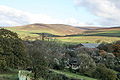
Oakenclough Works. In view is the paper mill, a shed manufacturer, and a scrapyard
-
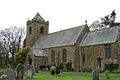
The church of St. John the Evangelist
External links
 Media related to Oakenclough at Wikimedia CommonsCategories:
- Villages in Lancashire
- Geography of Wyre
- Forest of Bowland
- Lancashire geography stubs
-


Wikimedia Foundation. 2010.